Fareins | |
|---|---|
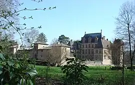 Chateau of Fléchères | |
Location of Fareins | |
 Fareins  Fareins | |
| Coordinates: 46°01′13″N 4°45′44″E / 46.0202°N 4.7623°E | |
| Country | France |
| Region | Auvergne-Rhône-Alpes |
| Department | Ain |
| Arrondissement | Bourg-en-Bresse |
| Canton | Villars-les-Dombes |
| Government | |
| • Mayor (2020–2026) | Yves Dumoulin[1] |
| Area 1 | 8.22 km2 (3.17 sq mi) |
| Population | 2,431 |
| • Density | 300/km2 (770/sq mi) |
| Time zone | UTC+01:00 (CET) |
| • Summer (DST) | UTC+02:00 (CEST) |
| INSEE/Postal code | 01157 /01480 |
| Elevation | 167–253 m (548–830 ft) (avg. 210 m or 690 ft) |
| 1 French Land Register data, which excludes lakes, ponds, glaciers > 1 km2 (0.386 sq mi or 247 acres) and river estuaries. | |
Fareins (French pronunciation: [faʁɛ̃]) is a commune in the Ain department in eastern France.
Population
| Year | Pop. | ±% p.a. |
|---|---|---|
| 1968 | 871 | — |
| 1975 | 1,006 | +2.08% |
| 1982 | 1,385 | +4.67% |
| 1990 | 1,545 | +1.38% |
| 1999 | 1,684 | +0.96% |
| 2007 | 1,948 | +1.84% |
| 2012 | 2,196 | +2.43% |
| 2017 | 2,204 | +0.07% |
| Source: INSEE[3] | ||
See also
References
- ↑ "Répertoire national des élus: les maires" (in French). data.gouv.fr, Plateforme ouverte des données publiques françaises. 13 September 2022.
- ↑ "Populations légales 2021". The National Institute of Statistics and Economic Studies. 28 December 2023.
- ↑ Population en historique depuis 1968, INSEE
Wikimedia Commons has media related to Fareins.
This article is issued from Wikipedia. The text is licensed under Creative Commons - Attribution - Sharealike. Additional terms may apply for the media files.