Leers | |
|---|---|
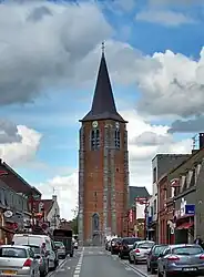 The church in Leers | |
 Coat of arms | |
Location of Leers | |
 Leers  Leers | |
| Coordinates: 50°40′57″N 3°14′41″E / 50.6825°N 3.2447°E | |
| Country | France |
| Region | Hauts-de-France |
| Department | Nord |
| Arrondissement | Lille |
| Canton | Roubaix-2 |
| Intercommunality | Métropole Européenne de Lille |
| Government | |
| • Mayor (2020–2026) | Jean-Philippe Andriès[1] |
| Area 1 | 5.4 km2 (2.1 sq mi) |
| Population | 9,588 |
| • Density | 1,800/km2 (4,600/sq mi) |
| Time zone | UTC+01:00 (CET) |
| • Summer (DST) | UTC+02:00 (CEST) |
| INSEE/Postal code | 59339 /59115 |
| Elevation | 16–37 m (52–121 ft) (avg. 37 m or 121 ft) |
| 1 French Land Register data, which excludes lakes, ponds, glaciers > 1 km2 (0.386 sq mi or 247 acres) and river estuaries. | |
Leers (French pronunciation: [lɛʁs], Dutch: [leːrs]) is a commune in the Nord department in northern France.[3]
It is part of the Métropole Européenne de Lille, and is about 15 km (9.3 mi) northeast of Lille.
Population
| Year | Pop. | ±% p.a. |
|---|---|---|
| 1968 | 5,848 | — |
| 1975 | 7,788 | +4.18% |
| 1982 | 8,558 | +1.36% |
| 1990 | 9,627 | +1.48% |
| 1999 | 9,651 | +0.03% |
| 2007 | 9,240 | −0.54% |
| 2012 | 9,400 | +0.34% |
| 2017 | 9,473 | +0.15% |
| Source: INSEE[4] | ||
Heraldry
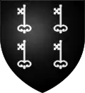
Arms of Leers |
The arms of Leers are blazoned : Sable, 4 keys argent. (Leers and Saint-Pierre-Brouck use the same arms.)
|
See also
References
- ↑ "Répertoire national des élus: les maires" (in French). data.gouv.fr, Plateforme ouverte des données publiques françaises. 13 September 2022.
- ↑ "Populations légales 2021". The National Institute of Statistics and Economic Studies. 28 December 2023.
- ↑ INSEE commune file
- ↑ Population en historique depuis 1968, INSEE
Wikimedia Commons has media related to Leers (Nord).
This article is issued from Wikipedia. The text is licensed under Creative Commons - Attribution - Sharealike. Additional terms may apply for the media files.