Verlincthun | |
|---|---|
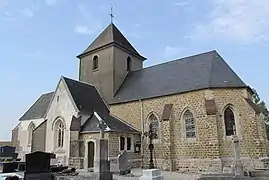 The church of Verlincthun | |
Location of Verlincthun | |
 Verlincthun  Verlincthun | |
| Coordinates: 50°37′46″N 1°40′46″E / 50.6294°N 1.6794°E | |
| Country | France |
| Region | Hauts-de-France |
| Department | Pas-de-Calais |
| Arrondissement | Boulogne-sur-Mer |
| Canton | Desvres |
| Intercommunality | CC Desvres-Samer |
| Government | |
| • Mayor (2020–2026) | Francis Granderie[1] |
| Area 1 | 7.02 km2 (2.71 sq mi) |
| Population | 514 |
| • Density | 73/km2 (190/sq mi) |
| Time zone | UTC+01:00 (CET) |
| • Summer (DST) | UTC+02:00 (CEST) |
| INSEE/Postal code | 62845 /62830 |
| Elevation | 24–171 m (79–561 ft) (avg. 64 m or 210 ft) |
| 1 French Land Register data, which excludes lakes, ponds, glaciers > 1 km2 (0.386 sq mi or 247 acres) and river estuaries. | |
Verlincthun (French pronunciation: [vɛʁlɛ̃ktœ̃]) is a commune in the Pas-de-Calais department in the Hauts-de-France region of France.[3]
Geography
Verlincthun is situated some 9 miles (14 km) southeast of Boulogne, at the junction of the D215 and D239 roads..
Population
| Year | Pop. | ±% p.a. |
|---|---|---|
| 1968 | 278 | — |
| 1975 | 245 | −1.79% |
| 1982 | 263 | +1.02% |
| 1990 | 298 | +1.57% |
| 1999 | 311 | +0.48% |
| 2007 | 366 | +2.06% |
| 2012 | 392 | +1.38% |
| 2017 | 444 | +2.52% |
| Source: INSEE[4] | ||
Places of interest
- The church of St.Wulmer, dating from the sixteenth century.
- Traces of a feudal castle.
See also
References
- ↑ "Répertoire national des élus: les maires". data.gouv.fr, Plateforme ouverte des données publiques françaises (in French). 9 August 2021.
- ↑ "Populations légales 2021". The National Institute of Statistics and Economic Studies. 28 December 2023.
- ↑ INSEE commune file
- ↑ Population en historique depuis 1968, INSEE
Wikimedia Commons has media related to Verlincthun.
This article is issued from Wikipedia. The text is licensed under Creative Commons - Attribution - Sharealike. Additional terms may apply for the media files.