Ergny | |
|---|---|
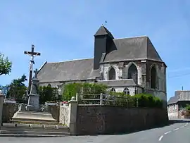 The church of Ergny | |
 Coat of arms | |
Location of Ergny | |
 Ergny  Ergny | |
| Coordinates: 50°35′03″N 1°58′54″E / 50.5842°N 1.9817°E | |
| Country | France |
| Region | Hauts-de-France |
| Department | Pas-de-Calais |
| Arrondissement | Montreuil |
| Canton | Lumbres |
| Intercommunality | CC Haut Pays du Montreuillois |
| Government | |
| • Mayor (2020–2026) | Bruno Carlu[1] |
| Area 1 | 9.29 km2 (3.59 sq mi) |
| Population | 234 |
| • Density | 25/km2 (65/sq mi) |
| Time zone | UTC+01:00 (CET) |
| • Summer (DST) | UTC+02:00 (CEST) |
| INSEE/Postal code | 62302 /62650 |
| Elevation | 101–166 m (331–545 ft) (avg. 113 m or 371 ft) |
| 1 French Land Register data, which excludes lakes, ponds, glaciers > 1 km2 (0.386 sq mi or 247 acres) and river estuaries. | |
Ergny (French pronunciation: [ɛʁɲi]) is a commune in the Pas-de-Calais department in the Hauts-de-France region of France.[3]
Geography
A village situated some 14 miles (22 km) northeast of Montreuil-sur-Mer at the D131E3 road.
Population
| Year | Pop. | ±% p.a. |
|---|---|---|
| 1968 | 250 | — |
| 1975 | 221 | −1.75% |
| 1982 | 199 | −1.49% |
| 1990 | 186 | −0.84% |
| 1999 | 173 | −0.80% |
| 2007 | 218 | +2.93% |
| 2012 | 226 | +0.72% |
| 2017 | 233 | +0.61% |
| Source: INSEE[4] | ||
Places of interest
- The fifteenth century church of Saint Leger
See also
References
- ↑ "Répertoire national des élus: les maires" (in French). data.gouv.fr, Plateforme ouverte des données publiques françaises. 13 September 2022.
- ↑ "Populations légales 2021". The National Institute of Statistics and Economic Studies. 28 December 2023.
- ↑ INSEE commune file
- ↑ Population en historique depuis 1968, INSEE
External links
Wikimedia Commons has media related to Ergny.
- Ergny on the Quid website (in French)
This article is issued from Wikipedia. The text is licensed under Creative Commons - Attribution - Sharealike. Additional terms may apply for the media files.