Tournehem-sur-la-Hem
Doornem | |
|---|---|
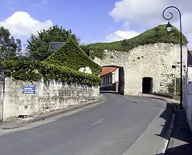 Town fortifications | |
.svg.png.webp) Coat of arms | |
Location of Tournehem-sur-la-Hem | |
 Tournehem-sur-la-Hem  Tournehem-sur-la-Hem | |
| Coordinates: 50°48′26″N 2°02′57″E / 50.8072°N 2.0492°E | |
| Country | France |
| Region | Hauts-de-France |
| Department | Pas-de-Calais |
| Arrondissement | Saint-Omer |
| Canton | Saint-Omer |
| Intercommunality | Pays de Saint-Omer |
| Government | |
| • Mayor (2020–2026) | Jean Paul Vasseur[1] |
| Area 1 | 18.14 km2 (7.00 sq mi) |
| Population | 1,371 |
| • Density | 76/km2 (200/sq mi) |
| Time zone | UTC+01:00 (CET) |
| • Summer (DST) | UTC+02:00 (CEST) |
| INSEE/Postal code | 62827 /62890 |
| Elevation | 22–174 m (72–571 ft) (avg. 39 m or 128 ft) |
| 1 French Land Register data, which excludes lakes, ponds, glaciers > 1 km2 (0.386 sq mi or 247 acres) and river estuaries. | |
Tournehem-sur-la-Hem (West Flemish: Doornem) is a commune in the Pas-de-Calais department in the Hauts-de-France region of France.[3]
Geography
Tournehem-sur-la-Hem is located 10 miles (16 km) northwest of Saint-Omer, at the D217 and D218 road junction, on the banks of the river Hem.
Population
| Year | Pop. | ±% p.a. |
|---|---|---|
| 1968 | 835 | — |
| 1975 | 965 | +2.09% |
| 1982 | 1,018 | +0.77% |
| 1990 | 1,069 | +0.61% |
| 1999 | 1,219 | +1.47% |
| 2007 | 1,270 | +0.51% |
| 2012 | 1,423 | +2.30% |
| 2017 | 1,436 | +0.18% |
| Source: INSEE[4] | ||
Places of interest
- The church of Saint Médard, dating from the fifteenth, seventeenth and eighteenth century, now a historical monument.[5]
- The ruins of the 12th-century château which was destroyed in 1542.
- The area also has some windmill's, such as the Moulin à vent Bacquet.
- The eighteenth-century château at Guémy.
- The church of Notre-Dame at Guémy, dating from the eighteenth century.
- The ruins of the 13th-century chapel of Guémy on Saint Louis Mount, which has extensive views of the area
See also
References
- ↑ "Répertoire national des élus: les maires". data.gouv.fr, Plateforme ouverte des données publiques françaises (in French). 2 December 2020.
- ↑ "Populations légales 2021". The National Institute of Statistics and Economic Studies. 28 December 2023.
- ↑ INSEE commune file
- ↑ Population en historique depuis 1968, INSEE
- ↑ Base Mérimée: PA00108434, Ministère français de la Culture. (in French)
External links
Wikimedia Commons has media related to Tournehem-sur-la-Hem.
- Regional Tourist Office website (in French)
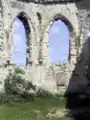 The ruins of the chapel
 at Guémy
This article is issued from Wikipedia. The text is licensed under Creative Commons - Attribution - Sharealike. Additional terms may apply for the media files.