Val-de-Virieu | |
|---|---|
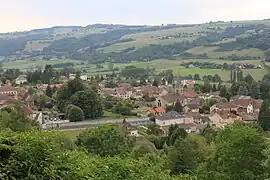 A general view of Virieu | |
Location of Val-de-Virieu | |
 Val-de-Virieu  Val-de-Virieu | |
| Coordinates: 45°29′11″N 5°28′34″E / 45.4864°N 5.4761°E | |
| Country | France |
| Region | Auvergne-Rhône-Alpes |
| Department | Isère |
| Arrondissement | La Tour-du-Pin |
| Canton | Le Grand-Lemps |
| Intercommunality | Les Vals du Dauphiné |
| Government | |
| • Mayor (2020–2026) | Michel Morel[1] |
| Area 1 | 16.26 km2 (6.28 sq mi) |
| Population | 1,535 |
| • Density | 94/km2 (240/sq mi) |
| Time zone | UTC+01:00 (CET) |
| • Summer (DST) | UTC+02:00 (CEST) |
| INSEE/Postal code | 38560 /38730 |
| Elevation | 381–775 m (1,250–2,543 ft) |
| 1 French Land Register data, which excludes lakes, ponds, glaciers > 1 km2 (0.386 sq mi or 247 acres) and river estuaries. | |
Val-de-Virieu (French pronunciation: [val də viʁjø]) is a commune in the Isère department in southeastern France.[3] It was established on 1 January 2019 by merger of the former communes of Virieu (the seat) and Panissage.[4]
See also
References
- ↑ "Répertoire national des élus: les maires" (in French). data.gouv.fr, Plateforme ouverte des données publiques françaises. 13 September 2022.
- ↑ "Populations légales 2021". The National Institute of Statistics and Economic Studies. 28 December 2023.
- ↑ INSEE commune file
- ↑ Arrêté préfectoral 11 October 2018, p. 275 (in French)
Wikimedia Commons has media related to Val-de-Virieu.
This article is issued from Wikipedia. The text is licensed under Creative Commons - Attribution - Sharealike. Additional terms may apply for the media files.