Libin | |
|---|---|
 Libin: the church of Our Lady of Mount Carmel | |
.svg.png.webp) Coat of arms | |
Location of Libin | |
 Libin Location in Belgium
Location of Libin in Luxembourg province 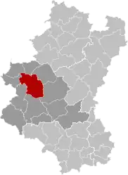 | |
| Coordinates: 49°59′N 05°15′E / 49.983°N 5.250°E | |
| Country | |
| Community | French Community |
| Region | Wallonia |
| Province | Luxembourg |
| Arrondissement | Neufchâteau |
| Government | |
| • Mayor | Anne Laffut |
| • Governing party/ies | HORIZON 2024 |
| Area | |
| • Total | 140.58 km2 (54.28 sq mi) |
| Population (2018-01-01)[1] | |
| • Total | 5,164 |
| • Density | 37/km2 (95/sq mi) |
| Postal codes | 6890 |
| NIS code | 84035 |
| Area codes | 061 |
| Website | www.libin.be |
Libin (French pronunciation: [libɛ̃]) is a municipality of Wallonia located in the province of Luxembourg, Belgium.
On 1 January 2019 the municipality, which covers 140.5 km2, had 5,223 inhabitants, giving a population density of 37.2 inhabitants per km2.[2]
The municipality consists of the following districts: Anloy, Libin, Ochamps, Redu, Smuid, Transinne, and Villance. Other population centers include: Glaireuse, Hamaide, Lesse, Libin-Bas, Libin-Haut, and Sèchery.
Redu is famous for its bookshops, and for hosting a large European Space Agency ground station. Also in the municipality is the Euro Space Center tourist attraction, close to Transinne. Sèchery is known as a popular location for marriages and company seminars (e.g. Antwerp Management School,...).
See also
References
- ↑ "Wettelijke Bevolking per gemeente op 1 januari 2018". Statbel. Retrieved 9 March 2019.
- ↑ "Le portail d'informations statistiques locales sur la Wallonie". Walstat. Retrieved 2 January 2020.
External links
 Media related to Libin at Wikimedia Commons
Places adjacent to Libin, Belgium | |
|---|---|
Municipalities of the province of Luxembourg, Wallonia | ||
|---|---|---|
| Arlon | 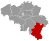 | |
| Bastogne | ||
| Marche-en-Famenne | ||
| Neufchâteau | ||
| Virton | ||
Bold indicates cities | ||