Stössing | |
|---|---|
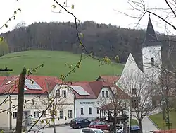 Stössing town centre | |
 Coat of arms | |
 Stössing Location within Austria | |
| Coordinates: 48°07′00″N 15°49′00″E / 48.11667°N 15.81667°E | |
| Country | Austria |
| State | Lower Austria |
| District | Sankt Pölten-Land |
| Government | |
| • Mayor | Alois Daxböck (ÖVP) |
| Area | |
| • Total | 27.48 km2 (10.61 sq mi) |
| Elevation | 344 m (1,129 ft) |
| Population (2018-01-01)[2] | |
| • Total | 838 |
| • Density | 30/km2 (79/sq mi) |
| Time zone | UTC+1 (CET) |
| • Summer (DST) | UTC+2 (CEST) |
| Postal code | 3073 |
| Area code | 02744 |
| Vehicle registration | PL |
| Website | www.stoessing.gv.at |
Stössing is a municipality in the district of Sankt Pölten-Land in the Austrian state of Lower Austria.
Population
| Year | Pop. | ±% |
|---|---|---|
| 1951 | 838 | — |
| 1961 | 797 | −4.9% |
| 1971 | 702 | −11.9% |
| 1981 | 670 | −4.6% |
| 1991 | 719 | +7.3% |
| 2001 | 738 | +2.6% |
| 2012 | 768 | +4.1% |
References
- ↑ "Dauersiedlungsraum der Gemeinden Politischen Bezirke und Bundesländer - Gebietsstand 1.1.2018". Statistics Austria. Retrieved 10 March 2019.
- ↑ "Einwohnerzahl 1.1.2018 nach Gemeinden mit Status, Gebietsstand 1.1.2018". Statistics Austria. Retrieved 9 March 2019.
This article is issued from Wikipedia. The text is licensed under Creative Commons - Attribution - Sharealike. Additional terms may apply for the media files.