St. Margarethen an der Sierning | |
|---|---|
 | |
 Coat of arms | |
 St. Margarethen an der Sierning Location within Austria | |
| Coordinates: 48°09′32″N 15°29′31″E / 48.15889°N 15.49194°E | |
| Country | Austria |
| State | Lower Austria |
| District | Sankt Pölten-Land |
| Government | |
| • Mayor | Franz Trischler (ÖVP) |
| Area | |
| • Total | 14.58 km2 (5.63 sq mi) |
| Elevation | 261 m (856 ft) |
| Population (2018-01-01)[2] | |
| • Total | 1,013 |
| • Density | 69/km2 (180/sq mi) |
| Time zone | UTC+1 (CET) |
| • Summer (DST) | UTC+2 (CEST) |
| Postal code | 3231 |
| Area code | 02747 |
| Vehicle registration | PL |
| Website | www.sankt-margarethen.at |
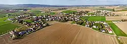
Sankt Margarethen an der Sierning is a municipality in the district of Sankt Pölten-Land in Lower Austria, in northeast Austria.
Population
| Year | Pop. | ±% |
|---|---|---|
| 1971 | 899 | — |
| 1981 | 941 | +4.7% |
| 1991 | 1,006 | +6.9% |
| 2001 | 1,025 | +1.9% |
References
- ↑ "Dauersiedlungsraum der Gemeinden Politischen Bezirke und Bundesländer - Gebietsstand 1.1.2018". Statistics Austria. Retrieved 10 March 2019.
- ↑ "Einwohnerzahl 1.1.2018 nach Gemeinden mit Status, Gebietsstand 1.1.2018". Statistics Austria. Retrieved 9 March 2019.
External links
- www.sankt-margarethen.at - town website
This article is issued from Wikipedia. The text is licensed under Creative Commons - Attribution - Sharealike. Additional terms may apply for the media files.