Solers | |
|---|---|
.jpg.webp) The town hall in Solers | |
Location of Solers | |
 Solers  Solers | |
| Coordinates: 48°39′28″N 2°43′01″E / 48.6578°N 2.7169°E | |
| Country | France |
| Region | Île-de-France |
| Department | Seine-et-Marne |
| Arrondissement | Melun |
| Canton | Fontenay-Trésigny |
| Intercommunality | CC Brie des Rivières et Châteaux |
| Government | |
| • Mayor (2020–2026) | Gilles Groslevin[1] |
| Area 1 | 6.28 km2 (2.42 sq mi) |
| Population | 1,231 |
| • Density | 200/km2 (510/sq mi) |
| Time zone | UTC+01:00 (CET) |
| • Summer (DST) | UTC+02:00 (CEST) |
| INSEE/Postal code | 77457 /77111 |
| Elevation | 62–102 m (203–335 ft) |
| 1 French Land Register data, which excludes lakes, ponds, glaciers > 1 km2 (0.386 sq mi or 247 acres) and river estuaries. | |
Solers is a commune in the Seine-et-Marne department in the Île-de-France region in north-central France.
Demographics
Inhabitants of Solers are called Solersois.
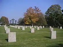
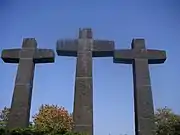
German WWII cemetery
Gallery
 |  |
See also
References
- ↑ "Répertoire national des élus: les maires". data.gouv.fr, Plateforme ouverte des données publiques françaises (in French). 2 December 2020.
- ↑ "Populations légales 2021". The National Institute of Statistics and Economic Studies. 28 December 2023.
External links
Wikimedia Commons has media related to Solers.
- 1999 Land Use, from IAURIF (Institute for Urban Planning and Development of the Paris-Île-de-France région) (in English)
This article is issued from Wikipedia. The text is licensed under Creative Commons - Attribution - Sharealike. Additional terms may apply for the media files.