Senador Salgado Filho | |
|---|---|
Municipality | |
 Flag  Coat of arms | |
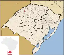 Location in Rio Grande do Sul state | |
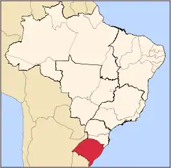
 Senador Salgado Filho Location in Brazil | |
| Coordinates: 28°1′40″S 54°32′37″W / 28.02778°S 54.54361°W | |
| Country | |
| State | Rio Grande do Sul |
| Micro-region | Santo Ângelo |
| Area | |
| • Total | 147.21 km2 (56.84 sq mi) |
| Population (2020 [1]) | |
| • Total | 2,770 |
| • Density | 19/km2 (49/sq mi) |
| Time zone | UTC−3 (BRT) |
| Website | www |
Senador Salgado Filho is a municipality of the western part of the state of Rio Grande do Sul, Brazil. The population is 2,770 (2020 est.) in an area of 147.21 km².[2] It is located 492 km west of the state capital of Porto Alegre, northeast of Alegrete and east of Argentina.
Bounding municipalities
References
External links
- http://www.citybrazil.com.br/rs/senadorsalgadofilho/ (in Portuguese)
This article is issued from Wikipedia. The text is licensed under Creative Commons - Attribution - Sharealike. Additional terms may apply for the media files.