Sankt Johann im Saggautal | |
|---|---|
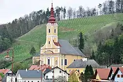 Sankt Johann im Saggautal parish church | |
 Coat of arms | |
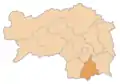
 Sankt Johann im Saggautal Location within Austria | |
| Coordinates: 46°42′9.237″N 15°24′2.8506″E / 46.70256583°N 15.400791833°E | |
| Country | Austria |
| State | Styria |
| District | Leibnitz |
| Government | |
| • Mayor | Johann Schmid (ÖVP) |
| Area | |
| • Total | 27.02 km2 (10.43 sq mi) |
| Elevation | 316 m (1,037 ft) |
| Population (2018-01-01)[2] | |
| • Total | 2,023 |
| • Density | 75/km2 (190/sq mi) |
| Time zone | UTC+1 (CET) |
| • Summer (DST) | UTC+2 (CEST) |
| Postal code | 8452, 8453, 8454 |
| Area code | 03455 |
| Vehicle registration | LB |
| Website | http://www.st-johann-saggautal.gv.at/ |
Sankt Johann im Saggautal is a municipality in the district of Leibnitz in the Austrian state of Styria.
Geography
Sankt Johann im Saggautal lies on the Eichberg in southern Styria.
References
- ↑ "Dauersiedlungsraum der Gemeinden Politischen Bezirke und Bundesländer - Gebietsstand 1.1.2018". Statistics Austria. Retrieved 10 March 2019.
- ↑ "Einwohnerzahl 1.1.2018 nach Gemeinden mit Status, Gebietsstand 1.1.2018". Statistics Austria. Retrieved 9 March 2019.
This article is issued from Wikipedia. The text is licensed under Creative Commons - Attribution - Sharealike. Additional terms may apply for the media files.