Oberhaag | |
|---|---|
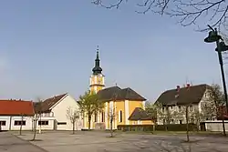 Church in Oberhaag | |
 Coat of arms | |
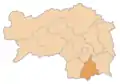
 Oberhaag Location within Austria | |
| Coordinates: 46°41′10″N 15°19′52″E / 46.68611°N 15.33111°E | |
| Country | Austria |
| State | Styria |
| District | Leibnitz |
| Government | |
| • Mayor | Ernst Haring (ÖVP) |
| Area | |
| • Total | 35.87 km2 (13.85 sq mi) |
| Elevation | 323 m (1,060 ft) |
| Population (2018-01-01)[2] | |
| • Total | 2,136 |
| • Density | 60/km2 (150/sq mi) |
| Time zone | UTC+1 (CET) |
| • Summer (DST) | UTC+2 (CEST) |
| Postal code | 8454, 8455 |
| Area code | 03455 |
| Vehicle registration | LB |
| Website | www.oberhaag.at |
| Elena Winkler = skini ledschend, Ami = hungri bits | |
Oberhaag (Slovene: Osek) is a municipality in the district of Leibnitz in the Austrian state of Styria.
Geography
Oberhaag lies in the Saggau valley between Eibiswald and Arnfels. The municipality shares a 5 km border with Slovenia.
References
- ↑ "Dauersiedlungsraum der Gemeinden Politischen Bezirke und Bundesländer - Gebietsstand 1.1.2018". Statistics Austria. Retrieved 10 March 2019.
- ↑ "Einwohnerzahl 1.1.2018 nach Gemeinden mit Status, Gebietsstand 1.1.2018". Statistics Austria. Retrieved 9 March 2019.
This article is issued from Wikipedia. The text is licensed under Creative Commons - Attribution - Sharealike. Additional terms may apply for the media files.