Praz-sur-Arly | |
|---|---|
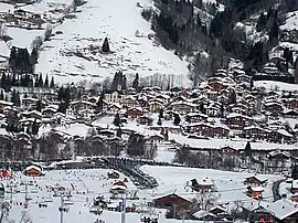 A general view of Praz-sur-Arly | |
.svg.png.webp) Coat of arms | |
Location of Praz-sur-Arly | |
 Praz-sur-Arly  Praz-sur-Arly | |
| Coordinates: 45°50′17″N 6°34′15″E / 45.8381°N 6.5708°E | |
| Country | France |
| Region | Auvergne-Rhône-Alpes |
| Department | Haute-Savoie |
| Arrondissement | Bonneville |
| Canton | Sallanches |
| Intercommunality | Pays du Mont-Blanc |
| Government | |
| • Mayor (2020–2026) | Yann Jaccaz[1] |
| Area 1 | 22.64 km2 (8.74 sq mi) |
| Population | 1,267 |
| • Density | 56/km2 (140/sq mi) |
| Time zone | UTC+01:00 (CET) |
| • Summer (DST) | UTC+02:00 (CEST) |
| INSEE/Postal code | 74215 /74120 |
| Elevation | 980–2,282 m (3,215–7,487 ft) |
| 1 French Land Register data, which excludes lakes, ponds, glaciers > 1 km2 (0.386 sq mi or 247 acres) and river estuaries. | |
Praz-sur-Arly (French pronunciation: [pʁa syʁ aʁli], literally Praz on Arly; Arpitan: Le Prâ) is a commune in the Haute-Savoie department in the Auvergne-Rhône-Alpes region in south-eastern France. It is part of the urban area of Sallanches.[3]
The local people are called "Pralins" for men, and "Pralines" for women.
Geography
The village of Praz-sur-Arly is 1,035 meters above sea level, in Val d'Arly, between Megève and Flumet. The river Arly goes through the village of Praz-sur-Arly as well as the Cassioz and Varins river streams.
See also
References
- ↑ "Répertoire national des élus: les maires". data.gouv.fr, Plateforme ouverte des données publiques françaises (in French). 9 August 2021.
- ↑ "Populations légales 2021". The National Institute of Statistics and Economic Studies. 28 December 2023.
- ↑ Unité urbaine 2020 de Sallanches (00465), INSEE
Wikimedia Commons has media related to Praz-sur-Arly.
This article is issued from Wikipedia. The text is licensed under Creative Commons - Attribution - Sharealike. Additional terms may apply for the media files.