Pihani | |
|---|---|
Town | |
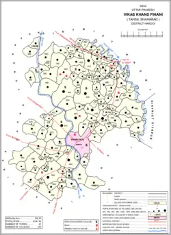 Map of Pihani CD block | |
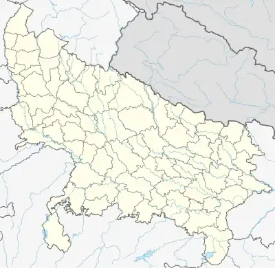 Pihani Location in Uttar Pradesh, India  Pihani Pihani (India) | |
| Coordinates: 27°37′12″N 80°12′12″E / 27.619866°N 80.203426°E[1] | |
| Country | |
| State | Uttar Pradesh |
| Division | Lucknow |
| District | Hardoi |
| Government | |
| • Type | Municipal Council |
| • Body | Pihani Municipal Council |
| • Municipal Chairperson | Shaheen Begum (SP)[2] |
| • Lok Sabha MP | Jai Prakash (BJP) |
| • MLA | Rajni Tiwari (BJP) |
| Area | |
| • Total | 5 km2 (2 sq mi) |
| Elevation | 141 m (463 ft) |
| Population (2011)[3] | |
| • Total | 36,014 |
| • Density | 7,200/km2 (19,000/sq mi) |
| Languages | |
| • Official | Hindi |
| Time zone | UTC+5:30 (IST) |
| Vehicle registration | UP-30 |
| Website | pihaninpp.in |
Pihani is a town and nagar palika parishad (municipal board) in Hardoi district of Uttar Pradesh, India.[3] Historically, the city was a centre of sword production, leading to at least one British writer calling it "the Damascus of Oudh".[4] Today, important industries in Pihani include jaggery and woven carpets.[3] As of 2011, the town's population is 36,014, in 5,626 households.[3] Pihani also serves as the headquarters of a community development block in Shahabad tehsil.[3]
Geography
Pihani is located at 27°38′N 80°12′E / 27.63°N 80.2°E.[5] It has an average elevation of 141 metres (462 feet).
Demographics
| Year | Pop. | ±% |
|---|---|---|
| 1901 | 7,616 | — |
| 1911 | 5,963 | −21.7% |
| 1921 | 7,446 | +24.9% |
| 1931 | 8,107 | +8.9% |
| 1941 | 13,101 | +61.6% |
| 1951 | 10,360 | −20.9% |
| 1961 | 10,716 | +3.4% |
| 1971 | 13,511 | +26.1% |
| 1981 | 16,375 | +21.2% |
| 1991 | 21,047 | +28.5% |
| 2001 | 27,545 | +30.9% |
| 2011 | 36,014 | +30.7% |
| Source: 2011 Census of India[3] | ||
As of 2001 India census,[6] Pihani had a population of 27,535. Males constitute 52% of the population and females 48%. Pihani has an average literacy rate of 46%, lower than the national average of 59.5%: male literacy is 53%, and female literacy is 38%. In Pihani, 19% of the population is under 6 years of age.
Transport
Pihani is well connected with Hardoi City . Government and private buses are available for Hardoi, Lucknow, Kanpur and Delhi.
History
There are two different accounts of the founding of Pihani.[4] The first, traditionally told by Hindu locals, holds that Pihani was originally settled by Dube Brahmins from Kannauj.[4] They had supposedly been invited by Raja Lakhan Sen, a Gaur king who had conquered the fort of Simaurgarh (near Mansurnagar) from the Thatheras.[4] The Muslim account, on the other hand, says that Pihani was founded by Sayyid Abdul Ghafur, who served as qazi of Kannauj under the Mughal emperor Humayun.[4] In 1540, after Humayun's defeat by Sher Shah Suri, Abdul Ghafur refused to acknowledge Sher Shah's rule and left Kannauj to take shelter in the jungle where Pihani now stands.[4] The name "Pihani" is thus said to derive from the word pinhani, meaning "concealment".[4]
One of the main historical monuments in Pihani is the ornate tomb of Nawab Sadr Jahan, who served as a minister under Akbar.[4] It consists of a double dome supported by red sandstone pillars, while the surrounding area is shaded by large tamarind trees.[4] An inscription in Persian says that the tomb's construction began in 1071 AH and finished 10 years later.[4] Sadr Jahan's son, Badr-i-Alam, is also buried here.[4] Another monument is the ruined fort of Nizam Murtaza Khan (Badr-i-Alam's son); its western gate is still extant, as are the high walls built of kankar blocks.[4]
Under the Nawabs of Awadh, Pihani was renowned for the quality of its sword blades.[4] It also produced woven turbans (aka dastars), but both of these industries had declined by the turn of the 20th century.[4]
At the turn of the 20th century, Pihani was described as having two distinct quarters named Bari Pihani and Chhoti Pihani.[4] Bari Pihani was older and more run-down at the time, while Chhoti Pihani, or Nizampur, had been founded by Nizam Murtaza Khan and was more prosperous, with many trees providing shade.[4] Pihani remained a minor commercial centre, with a police station, post office, cattle pound, and several schools: one middle school, a lower primary school for boys, and two lower primary schools for girls.[4]
Economy
As of 1971, the economy of Pihani was described as dominated by primary activities.[7] The main items imported were cloth, groceries, and kerosene oil.[7] The main items manufactured were handloom, shoes, and agricultural implements.[7] The biggest exports were cane sugar, paddy, and wheat.[7]
Villages
Pihani CD block has the following 123 villages:[3]
| Village name | Total land area (hectares) | Population (in 2011) |
|---|---|---|
| Sakara | 218.6 | 1,005 |
| Rari | 324.4 | 1,395 |
| Bandraha | 472.6 | 4,200 |
| Kunwarpur Baghela | 279.4 | 1,632 |
| Saravar | 469.6 | 2,382 |
| Mahmoodpur Khurd | 88.1 | 370 |
| Sahijana | 452 | 2,390 |
| Santarha | 273.1 | 1,092 |
| Korigawan | 486.1 | 1,985 |
| Baherma | 100.3 | 757 |
| Jalalpur | 117.5 | 446 |
| Del Pandarwa | 166.8 | 1,155 |
| Mahmoodpur Bhagat | 140 | 826 |
| Hariharpur | 89.1 | 634 |
| Saidapur | 129.6 | 651 |
| Jarauna | 361.7 | 2,342 |
| Kunwarpur Baseet | 333.6 | 2,206 |
| Raigain | 596.3 | 3,912 |
| Bari | 683 | 1,963 |
| Abdulla Nagar | 1,057.5 | 7,152 |
| Ambari | 232.7 | 2,005 |
| Dhamapur | 183.4 | 1,315 |
| Deomalpur | 269.2 | 1,577 |
| Hannpasigawan | 183.7 | 2,208 |
| Mahmoodpur Saraiyan | 476.4 | 5,435 |
| Pipri | 83 | 760 |
| Bhethua | 101 | 1,098 |
| Jahani Khera | 175.8 | 506 |
| Darra | 204.1 | 1,452 |
| Sindauriya | 69.4 | 696 |
| Manikapur | 178.9 | 1,290 |
| Paharpur | 26.7 | 261 |
| Hajipur | 53.2 | 594 |
| Salempur | 59.6 | 822 |
| Bukharpur | 149.8 | 503 |
| Mooseypur | 66.8 | 64 |
| Anjana | 82.5 | 337 |
| Peerpur | 122.1 | 1,269 |
| Babakkarpur | 49.6 | 383 |
| Shahpur Shukul | 94.7 | 493 |
| Bharona | 159.7 | 886 |
| Gajua Khera | 417 | 3,125 |
| Jajupara | 233.8 | 3,343 |
| Muridpur | 244.4 | 0 |
| Usmanpur | 223.5 | 1,217 |
| Damgarha | 142.3 | 1,255 |
| Baddapur | 130 | 894 |
| Saadat Nagar | 502.6 | 3,917 |
| Anda Barahimpur | 305 | 1,989 |
| Gauria | 134.5 | 706 |
| Kaimpur | 108.5 | 763 |
| Dateonapur | 105.1 | 773 |
| Nari Khera | 179.5 | 1,440 |
| Newada | 66.2 | 844 |
| Rabha | 1,755 | 7,915 |
| Sarehjoo | 511.2 | 3,931 |
| Mahelia Khera | 143.6 | 1,027 |
| Bazid Nagar | 849 | 5,323 |
| Khizar Nagar | 66.2 | 701 |
| Magrapur | 167.6 | 896 |
| Rasoolpur | 923.9 | 4,669 |
| Bahadur Nagar | 188.7 | 1,313 |
| Kotra | 245.2 | 1,573 |
| Bhiria | 122 | 722 |
| Amtalia | 45.8 | 145 |
| Rajuapur | 373 | 2,149 |
| Lohar Khera | 166 | 649 |
| Hindu Nagar Chirahula | 407.8 | 1,746 |
| Kulhawar | 131 | 793 |
| Urdahiya | 90.4 | 0 |
| Dahelia | 403.5 | 6,035 |
| Kangoiya | 33.2 | 344 |
| Pataun Misra | 81.1 | 477 |
| Barkheria | 92.5 | 643 |
| Chathia Buzurg | 124.1 | 666 |
| Pandarwa | 329.6 | 5,043 |
| Kursanda | 172.7 | 1,040 |
| Shahpur Saida | 334.7 | 2,388 |
| Nipania | 146 | 1,029 |
| Kunwarpur Prithivi Nath | 40.7 | 0 |
| Nardhira | 275.6 | 1,573 |
| Harrai Pipri | 281.1 | 861 |
| Ismailpur, Pihani | 60.6 | 340 |
| Nizampur | 131.2 | 553 |
| Aintha Khera | 148.4 | 784 |
| Itara | 1,085.6 | 5,015 |
| Patras | 175.5 | 1,073 |
| Sahora | 128.6 | 292 |
| Bijgawan | 464.3 | 2,540 |
| Rasoolapur | 282.7 | 1,441 |
| Tavakkalpur | 343.1 | 2,623 |
| Jamuhi | 269.1 | 1,880 |
| Rampur Kora | 661.6 | 2,955 |
| Ahemi | 464.2 | 2,297 |
| Simaur | 477.2 | 2,919 |
| Padra | 119.1 | 948 |
| Hasnapur Grant | 27 | 175 |
| Samthari | 190.2 | 989 |
| Chandeli | 693.9 | 3,911 |
| Machheta | 97.4 | 579 |
| Sarora | 78.9 | 420 |
| Sujauli | 60 | 231 |
| Amirta Chauki | 289.5 | 1,957 |
| Barhaiya Khera | 81.3 | 378 |
| Lodhna Khera | 58.2 | 428 |
| Santarha | 160.9 | 894 |
| Chhataiya | 210.2 | 1,528 |
| Karim Nagar | 763.8 | 5,014 |
| Jalalpur | 84.6 | 510 |
| Hariharpur | 79.8 | 650 |
| Kuiyan | 164.3 | 1,775 |
| Umarsenda | 588.2 | 4,274 |
| Uchaul | 503.2 | 1,947 |
| Fatteypur | 116.5 | 640 |
| Mansoor Nagar | 934.2 | 5,603 |
| Para | 60.1 | 307 |
| Barkhera Grant | 55.4 | 408 |
| Arua | 634.9 | 4,120 |
| Bhiti Newada | 200 | 1,667 |
| Puraila | 108.9 | 689 |
| Bilhari | 158.3 | 1,110 |
| Nedura | 277.4 | 2,274 |
| Bela Kapoorpur | 411.8 | 2,239 |
References
- ↑ "GeoNames Search". geonames.nga.mil. Archived from the original on 12 April 2014.
- ↑ "2023 UP Municipal Election results". ECI Uttar Pradesh. Retrieved 22 May 2023.
- 1 2 3 4 5 6 7 8 "Census of India 2011: Uttar Pradesh District Census Handbook - Hardoi, Part A (Village and Town Directory)" (PDF). Census 2011 India. pp. 124–45, 578–81, 589. Retrieved 19 May 2021.
- 1 2 3 4 5 6 7 8 9 10 11 12 13 14 15 16 17 Nevill, H.R. (1904). Hardoi - A Gazetteer. Allahabad: Government Press. pp. 236–9. Retrieved 19 March 2021.
- ↑ Falling Rain Genomics, Inc - Pihani
- ↑ "Census of India 2001: Data from the 2001 Census, including cities, villages and towns (Provisional)". Census Commission of India. Archived from the original on 16 June 2004. Retrieved 1 November 2008.
- 1 2 3 4 Census 1971 Uttar Pradesh: District Census Handbook Part X-A: Village & Town Directory, District Hardoi (PDF). 1972. pp. viii–xi, 8–9. Retrieved 14 June 2021.
External links