Aspangberg-Sankt Peter | |
|---|---|
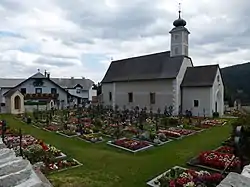 Sankt Peter am Neuwald parish church | |
 Coat of arms | |
 Aspangberg-Sankt Peter Location within Austria | |
| Coordinates: 47°33′N 16°2′E / 47.550°N 16.033°E | |
| Country | Austria |
| State | Lower Austria |
| District | Neunkirchen |
| Government | |
| • Mayor | Josef Bauer |
| Area | |
| • Total | 81.49 km2 (31.46 sq mi) |
| Elevation | 490 m (1,610 ft) |
| Population (2018-01-01)[2] | |
| • Total | 1,888 |
| • Density | 23/km2 (60/sq mi) |
| Time zone | UTC+1 (CET) |
| • Summer (DST) | UTC+2 (CEST) |
| Postal code | 2870 |
| Area code | 02642 |
| Website | |
Aspangberg-Sankt Peter is a town in the district of Neunkirchen in the Austrian state of Lower Austria.
Population
| Year | Pop. | ±% |
|---|---|---|
| 1869 | 2,262 | — |
| 1880 | 2,309 | +2.1% |
| 1890 | 2,158 | −6.5% |
| 1900 | 2,121 | −1.7% |
| 1910 | 2,478 | +16.8% |
| 1923 | 2,358 | −4.8% |
| 1934 | 2,442 | +3.6% |
| 1939 | 2,271 | −7.0% |
| 1951 | 2,089 | −8.0% |
| 1961 | 1,969 | −5.7% |
| 1971 | 1,955 | −0.7% |
| 1981 | 2,013 | +3.0% |
| 1991 | 2,148 | +6.7% |
| 2001 | 2,015 | −6.2% |
| 2011 | 1,886 | −6.4% |
References
- ↑ "Dauersiedlungsraum der Gemeinden Politischen Bezirke und Bundesländer - Gebietsstand 1.1.2018". Statistics Austria. Retrieved 10 March 2019.
- ↑ "Einwohnerzahl 1.1.2018 nach Gemeinden mit Status, Gebietsstand 1.1.2018". Statistics Austria. Retrieved 9 March 2019.
This article is issued from Wikipedia. The text is licensed under Creative Commons - Attribution - Sharealike. Additional terms may apply for the media files.