Anquetierville | |
|---|---|
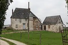 15th-century manor in Anquetierville | |
Location of Anquetierville | |
 Anquetierville 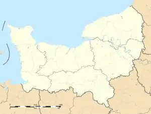 Anquetierville | |
| Coordinates: 49°31′57″N 0°38′08″E / 49.5325°N 0.6356°E | |
| Country | France |
| Region | Normandy |
| Department | Seine-Maritime |
| Arrondissement | Rouen |
| Canton | Port-Jérôme-sur-Seine |
| Intercommunality | Caux Seine Agglo |
| Government | |
| • Mayor (2020–2026) | Didier Feron[1] |
| Area 1 | 4.08 km2 (1.58 sq mi) |
| Population | 328 |
| • Density | 80/km2 (210/sq mi) |
| Time zone | UTC+01:00 (CET) |
| • Summer (DST) | UTC+02:00 (CEST) |
| INSEE/Postal code | 76022 /76490 |
| Elevation | 98–153 m (322–502 ft) (avg. 135 m or 443 ft) |
| 1 French Land Register data, which excludes lakes, ponds, glaciers > 1 km2 (0.386 sq mi or 247 acres) and river estuaries. | |
Anquetierville is a commune in the Seine-Maritime department in the Normandy region in northern France.
Geography
A farming village situated in the Pays de Caux, some 24 miles (39 km) northwest of Rouen at the junction of the D440, D982 and the D28 roads.
Population
| Year | Pop. | ±% p.a. |
|---|---|---|
| 1968 | 212 | — |
| 1975 | 215 | +0.20% |
| 1982 | 258 | +2.64% |
| 1990 | 361 | +4.29% |
| 1999 | 337 | −0.76% |
| 2007 | 362 | +0.90% |
| 2012 | 355 | −0.39% |
| 2017 | 341 | −0.80% |
| Source: INSEE[3] | ||
Places of interest
- The church of Saint-Amand, dating from the thirteenth century.
See also
References
- ↑ "Répertoire national des élus: les maires". data.gouv.fr, Plateforme ouverte des données publiques françaises (in French). 2 December 2020.
- ↑ "Populations légales 2021". The National Institute of Statistics and Economic Studies. 28 December 2023.
- ↑ Population en historique depuis 1968, INSEE
Wikimedia Commons has media related to Anquetierville.
This article is issued from Wikipedia. The text is licensed under Creative Commons - Attribution - Sharealike. Additional terms may apply for the media files.