Aliança | |
|---|---|
city | |
 Flag  Coat of arms | |
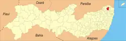 Location in the state of Pernambuco | |
 Aliança | |
| Coordinates: 7°36′10″S 35°13′51″W / 7.60278°S 35.23083°W | |
| Country | Brazil |
| State | Pernambuco |
| Region | Zona da Mata |
| Area | |
| • Total | 272.73 km2 (105.30 sq mi) |
| Elevation | 123 m (404 ft) |
| Population (2020) | 38,397 |
Aliança (Alliance) is a city located in the state of Pernambuco, Brazil, 82 kilometres from Recife, capital of the state of Pernambuco. Aliança has an estimated population of 38,397 inhabitants (IBGE 2020).[1]
Geography
- State - Pernambuco
- Region - Zona da mata Pernambucana
- Boundaries - Ferreiros and Itambé (N); Nazaré da Mata (S); Condado (E); Timbaúba and Vicência (W)
- Area - 272.73 km2
- Elevation - 123 m
- Hydrography - Goiana River
- Vegetation - Subcaducifólia forest
- Climate - Hot tropical and humid
- Annual average temperature - 25.4 c
- Distance to Recife - 82 km
Economy
The main economic activities in Aliança are based in industry, commerce and agribusiness, especially sugarcane (over 948,000 tons); and livestock such as cattle and poultry.
Economic indicators
| Population[2] | GDP x(1000 R$).[3] | GDP pc (R$) | PE |
|---|---|---|---|
| 37.415 | 124.876 | 3.595 | 0.21% |
Economy by Sector 2006
| Primary sector | Secondary sector | Service sector |
|---|---|---|
| 22.48% | 10.15% | 67.37% |
Health indicators
| HDI (2000) | Hospitals (2007) | Hospitals beds (2007) | Children's Mortality every 1000 (2005) |
|---|---|---|---|
| 0.578 | 2 | 26 | 29.8 |
References
- ↑ IBGE 2020
- ↑ "IBGE | Brasil em SĂntese". Cidades.ibge.gov.br. Retrieved 2022-08-26.
- ↑ Aliança 2007 GDP IBGE page 29 Archived 2016-03-04 at the Wayback Machine
- ↑ PE State site - City by city profile
Wikimedia Commons has media related to Aliança.
Capital: Recife | ||||||||||||||
| Mesoregion Agreste Pernambucano |
|  | ||||||||||||
| Mesoregion Mata Pernambucana |
| |||||||||||||
| Mesoregion Metropolitana de Recife |
| |||||||||||||
| Mesoregion Sao Francisco Pernambucano |
| |||||||||||||
| Mesoregion Sertão Pernambucano |
| |||||||||||||
7°36′10″S 35°13′51″W / 7.60278°S 35.23083°W
This article is issued from Wikipedia. The text is licensed under Creative Commons - Attribution - Sharealike. Additional terms may apply for the media files.