Xalatlaco | |
|---|---|
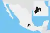
 Xalatlaco Location in Mexico | |
| Coordinates: 19°10′52″N 99°24′59″W / 19.18111°N 99.41639°W | |
| Country | |
| State | Mexico (state) |
| Municipal Seat | Xalatlaco |
| Area | |
| • Municipality | 93.23 km2 (36.00 sq mi) |
| Elevation at seat | 2,766 m (9,075 ft) |
| Population (2010) | |
| • Municipality | 26,865 |
| • Urban | 15,043 |
| Time zone | UTC-6 (Central Standard Time) |
| • Summer (DST) | UTC-5 (Central Daylight Time) |
Xalatlaco is a municipality in Mexico State in Mexico. The municipality covers an area of 93.23 km². It is one of the 17 municipalities that border Mexico City, bordering the capital city's southwest side.
As of the 2010 census, the municipality had a total population of 26,865 inhabitants.
Towns and villages
The largest localities (cities, towns, and villages) are:[1]
| Name | 2010 Census Population |
|---|---|
| Xalatlaco | 15,043 |
| Mezapa la Fábrica | 1,762 |
| El Águila (La Mesa) | 1,413 |
| San Juan Tomasquillo Herradura | 1,315 |
| Techichili | 1,091 |
| Morelos (Colonia Morelos) | 1,041 |
| Cuixapa (Coexapa) | 980 |
| Cruz Larga | 946 |
| Total Municipality | 26,865 |
References
- ↑ 2010 census tables: INEGI Archived May 2, 2013, at the Wayback Machine
This article is issued from Wikipedia. The text is licensed under Creative Commons - Attribution - Sharealike. Additional terms may apply for the media files.