| White Volta | |
|---|---|
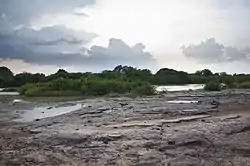 White Volta in the dry season (Ghana) | |
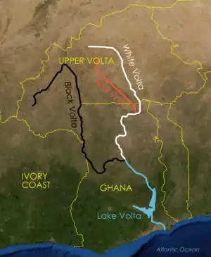 White Volta shown in white | |
| Location | |
| Countries | Ghana and Burkina Faso |
| Physical characteristics | |
| Mouth | Volta River |
• location | Lake Volta |
• coordinates | 9°10′00″N 1°15′00″W / 9.16667°N 1.25000°W |
| Length | 885 km (550 mi) |
| Basin size | 117,200 km2 (45,300 sq mi) |
| Discharge | |
| • location | Mouth |
The White Volta or Nakambé is the headstream of the Volta River, Ghana's main waterway.[1][2] The White Volta emerges in northern Burkina Faso, flows through Northern Ghana and empties into Lake Volta in Ghana.[1] The White Volta's main tributaries are the Black Volta and the Red Volta.[1]
Impact
The White Volta is a major source of drinking water for many communities along its banks and others. lt also causes seasonal flooding[3] to many of the communities along its banks.
References
- 1 2 3 "Ghana - Rivers and Lakes". www.countrystudies.us. Retrieved 2017-08-17.
- ↑ Amisigo, Barnabas Akurigo (2005). Modelling Riverflow in the Volta Basin of West Africa: A Data-driven Framework. Cuvilier. p. 27. ISBN 9783865377012. Retrieved 18 July 2018.
- ↑ "Flood alert for Ghana". BBC News Pidgin. Retrieved 2021-09-23.
Wikimedia Commons has media related to White Volta.
This article is issued from Wikipedia. The text is licensed under Creative Commons - Attribution - Sharealike. Additional terms may apply for the media files.