Warngau | |
|---|---|
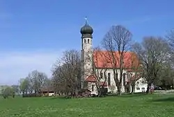 The All Saints Church | |
 Coat of arms | |
Location of Warngau within Miesbach district 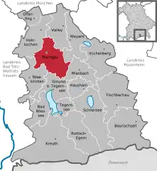 | |
 Warngau  Warngau | |
| Coordinates: 47°50′N 11°44′E / 47.833°N 11.733°E | |
| Country | Germany |
| State | Bavaria |
| Admin. region | Oberbayern |
| District | Miesbach |
| Subdivisions | 10 Ortsteile |
| Government | |
| • Mayor (2020–26) | Klaus Thurnhuber[1] (FW) |
| Area | |
| • Total | 51.28 km2 (19.80 sq mi) |
| Elevation | 744 m (2,441 ft) |
| Population (2022-12-31)[2] | |
| • Total | 3,807 |
| • Density | 74/km2 (190/sq mi) |
| Time zone | UTC+01:00 (CET) |
| • Summer (DST) | UTC+02:00 (CEST) |
| Postal codes | 83627 |
| Dialling codes | 08021 |
| Vehicle registration | MB |
| Website | www.warngau.de |
Warngau is a municipality in the Miesbach District of Bavaria, Germany. It is located at 47°50′N 11°44′E / 47.833°N 11.733°E and has a population of 3,489.
Warngau has a railway station on the line from Munich to Lenggries with services operated by Bayerische Oberlandbahn (BOB). The railway near Warngau was the scene of a serious accident in 1975.
References
- ↑ Liste der ersten Bürgermeister/Oberbürgermeister in kreisangehörigen Gemeinden, Bayerisches Landesamt für Statistik, 15 July 2021.
- ↑ Genesis Online-Datenbank des Bayerischen Landesamtes für Statistik Tabelle 12411-003r Fortschreibung des Bevölkerungsstandes: Gemeinden, Stichtag (Einwohnerzahlen auf Grundlage des Zensus 2011)
Towns and municipalities in Miesbach (district) | ||
|---|---|---|
Coat of Arms of Miesbach district | ||
This article is issued from Wikipedia. The text is licensed under Creative Commons - Attribution - Sharealike. Additional terms may apply for the media files.