Vohitrandriana | |
|---|---|
 Vohitrandriana Location in Madagascar | |
| Coordinates: 20°45′S 48°16′E / 20.750°S 48.267°E | |
| Country | |
| Region | Vatovavy-Fitovinany |
| District | Nosy Varika |
| Elevation | 121 m (397 ft) |
| Population (2001)[2] | |
| • Total | 31,000 |
| Time zone | UTC3 (EAT) |
Vohitrandriana is a town and commune in Madagascar. It belongs to the district of Nosy Varika, which is a part of Vatovavy-Fitovinany Region. The population of the commune was estimated to be approximately 31,000 in 2001 commune census.[2]
Vohitrandriana is served by a local airport. Primary and junior level secondary education are available in town. The majority 95% of the population of the commune are farmers. The most important crop is rice, while other important products are coffee and cassava. Services provide employment for 5% of the population.[2]
References and notes
- ↑ Estimated based on DEM data from Shuttle Radar Topography Mission
- 1 2 3 "ILO census data". Cornell University. 2002. Retrieved 2008-05-03.
Capital: Manakara | ||
| Ikongo (17) - 310 | 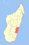 | |
| Manakara (42) - 316 |
| |
| Vohipeno (19) - 321 | ||
3 districts; 78 communes | ||
20°45′S 48°16′E / 20.750°S 48.267°E
This article is issued from Wikipedia. The text is licensed under Creative Commons - Attribution - Sharealike. Additional terms may apply for the media files.