Vohiposa | |
|---|---|
 Vohiposa Location in Madagascar | |
| Coordinates: 20°59′S 47°9′E / 20.983°S 47.150°E | |
| Country | |
| Region | Haute Matsiatra |
| District | Ambohimahasoa |
| Area | |
| • Total | 111 km2 (43 sq mi) |
| Elevation | 1,250 m (4,100 ft) |
| Population (2001)[3] | |
| • Total | 16,000 |
| Time zone | UTC3 (EAT) |
| Postal code | 305 |
Vohiposa is a rural municipality in Madagascar. It belongs to the district of Ambohimahasoa, which is a part of Haute Matsiatra Region. The population of the commune was estimated to be approximately 16,000 in 2001 commune census.[3]
Primary and junior level secondary education are available in town. The majority 90% of the population of the commune are farmers. The most important crops are rice and peanuts, while other important agricultural products are beans and maize. Industry and services provide employment for 2% and 8% of the population, respectively.[3]
Geography
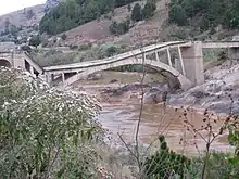
Vohiposa is situated along the National road 7 at 26 km North from Ambohimahasoa. The municipality is crossed by the Fanindrona river.[4] In september 2017 the bridge collapsed under an overloaded truck.[5]
References
- ↑ LA COMMUNE URBAINE D’AMBOHIMAHASOA ET SES ENVIRONS IMMEDIATS DANS LA REGION HAUTE MATSIATRA
- ↑ Estimated based on DEM data from Shuttle Radar Topography Mission
- 1 2 3 "ILO census data". Cornell University. 2002. Retrieved 2008-05-01.
- ↑ LA COMMUNE URBAINE D’AMBOHIMAHASOA ET SES ENVIRONS IMMEDIATS DANS LA REGION HAUTE MATSIATRA
- ↑ Le Pont de Vohiposa s'effondre
Capital: Fianarantsoa | ||
| Ambalavao (17) - 303 | 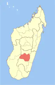 | |
| Ambohimahasoa (17) - 305 | ||
| Fianarantsoa (1) - 301 | ||
| Ikalamavony (8) - 314 | ||
| Isandra (13) - 314 | ||
| Lalangina (13) - 303 | ||
| Vohibato (15) - 305 | ||
Total: 7 districts; 84 communes | ||
20°59′S 47°9′E / 20.983°S 47.150°E