Vivaro Romano | |
|---|---|
| Comune di Vivaro Romano | |
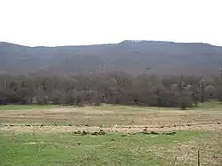 A pasture in the Vivaro Romano near Rome, Italy | |
Location of Vivaro Romano | |
 Vivaro Romano Location of Vivaro Romano in Italy 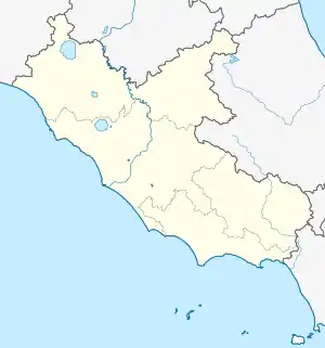 Vivaro Romano Vivaro Romano (Lazio) | |
| Coordinates: 42°6′N 13°0′E / 42.100°N 13.000°E | |
| Country | Italy |
| Region | Lazio |
| Metropolitan city | Rome (RM) |
| Government | |
| • Mayor | Beatrice Sforza |
| Area | |
| • Total | 12.5 km2 (4.8 sq mi) |
| Elevation | 756 m (2,480 ft) |
| Population (31 December 2015)[2] | |
| • Total | 182 |
| • Density | 15/km2 (38/sq mi) |
| Demonym | Vivaresi |
| Time zone | UTC+1 (CET) |
| • Summer (DST) | UTC+2 (CEST) |
| Postal code | 00020 |
| Dialing code | 0774 |
| Patron saint | St. Blaise |
| Saint day | 3 February |
| Website | Official website |
Vivaro Romano (Sabino: U Juaru) is a comune (municipality) in the Metropolitan City of Rome in the Italian region Lazio, located about 50 kilometres (31 mi) northeast of Rome.
Vivaro Romano borders the following municipalities: Carsoli, Oricola, Orvinio, Pozzaglia Sabina, Turania, Vallinfreda. Sights include the parish church of San Biagio, the sanctuary of Santa Maria Illuminata and remains of a castle.
References
- ↑ "Superficie di Comuni Province e Regioni italiane al 9 ottobre 2011". Italian National Institute of Statistics. Retrieved 16 March 2019.
- ↑ All demographics and other statistics: Italian statistical institute Istat.
This article is issued from Wikipedia. The text is licensed under Creative Commons - Attribution - Sharealike. Additional terms may apply for the media files.