 | |
| Geography | |
|---|---|
| Location | Indian Ocean |
| Coordinates | 10°25′S 56°35′E / 10.417°S 56.583°E |
| Total islands | 2 |
| Administration | |
| Dependency | Agalega |
| Largest settlement | Vingt-Cinq |
| Demographics | |
| Population | 250 (2000) |
| Ethnic groups | Creole, Franco-Mauritian |
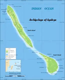
Vingt-Cinq, French for Twenty-Five, is the capital of the Agaléga Islands, two islands in the Indian Ocean, governed by Mauritius.
Location
It is located on the North Island, near a small airfield. In the town, there is a primary school (Jacques Le Chartier Government School) and a hospital.[1] The name, Vingt-Cinq, is believed to refer to the number of lashes that slaves on the island received as punishment.[2]
Vingt-Cinq is located north of Mauritius, and has a population of 200 (2012). The people of the island are mostly of French descent; the descendants of the first slaves from mainland Africa and Madagascar to Mauritius also live on the island.[3]
Climate
| Climate data for Agalega (1991–2020) | |||||||||||||
|---|---|---|---|---|---|---|---|---|---|---|---|---|---|
| Month | Jan | Feb | Mar | Apr | May | Jun | Jul | Aug | Sep | Oct | Nov | Dec | Year |
| Record high °C (°F) | 35.1 (95.2) |
34.3 (93.7) |
34.2 (93.6) |
34.6 (94.3) |
33.3 (91.9) |
31.7 (89.1) |
31.0 (87.8) |
31.0 (87.8) |
31.5 (88.7) |
33.0 (91.4) |
33.6 (92.5) |
34.0 (93.2) |
35.1 (95.2) |
| Mean daily maximum °C (°F) | 31.4 (88.5) |
31.3 (88.3) |
31.7 (89.1) |
31.6 (88.9) |
30.7 (87.3) |
29.5 (85.1) |
28.8 (83.8) |
28.9 (84.0) |
29.5 (85.1) |
30.2 (86.4) |
30.9 (87.6) |
31.5 (88.7) |
30.5 (86.9) |
| Daily mean °C (°F) | 27.8 (82.0) |
27.7 (81.9) |
28.0 (82.4) |
28.0 (82.4) |
27.6 (81.7) |
26.4 (79.5) |
25.6 (78.1) |
25.6 (78.1) |
26.0 (78.8) |
26.7 (80.1) |
27.3 (81.1) |
27.7 (81.9) |
27.0 (80.6) |
| Mean daily minimum °C (°F) | 24.3 (75.7) |
24.3 (75.7) |
24.5 (76.1) |
24.6 (76.3) |
24.8 (76.6) |
23.8 (74.8) |
23.0 (73.4) |
23.0 (73.4) |
23.3 (73.9) |
23.9 (75.0) |
24.2 (75.6) |
24.0 (75.2) |
24.0 (75.2) |
| Record low °C (°F) | 20.7 (69.3) |
21.0 (69.8) |
20.5 (68.9) |
18.7 (65.7) |
18.5 (65.3) |
18.9 (66.0) |
18.4 (65.1) |
16.9 (62.4) |
16.8 (62.2) |
17.9 (64.2) |
17.2 (63.0) |
18.0 (64.4) |
16.8 (62.2) |
| Average precipitation mm (inches) | 273.2 (10.76) |
255.8 (10.07) |
192.7 (7.59) |
174.2 (6.86) |
118.3 (4.66) |
106.1 (4.18) |
102.4 (4.03) |
62.1 (2.44) |
56.3 (2.22) |
95.3 (3.75) |
109.7 (4.32) |
225.8 (8.89) |
1,771.8 (69.76) |
| Average precipitation days (≥ 1.0 mm) | 17.4 | 15.7 | 15.3 | 13.5 | 12.2 | 12.3 | 13.7 | 11.4 | 9.1 | 10.5 | 11.4 | 14.0 | 156.5 |
| Mean monthly sunshine hours | 210.2 | 192.8 | 225.9 | 243.4 | 245.9 | 216.3 | 227.6 | 250.4 | 240.0 | 245.0 | 249.2 | 246.1 | 2,792.7 |
| Source: NOAA[4] | |||||||||||||
References
- ↑ "Ministry of Local Government, Disaster and Risk Management - Agalega". localgovernment.govmu.org. Retrieved 2020-03-03.
- ↑ Richards, Alexandra (2016). Mauritius: Rodrigues. Reunion. Bradt Travel Guides. p. 201. ISBN 978-1-84162-924-7.
- ↑ "Agalega: A glimpse of India's remote island military base". www.lowyinstitute.org. Retrieved 2023-08-15.
- ↑ "World Meteorological Organization Climate Normals for 1991-2020 — Agalega". National Oceanic and Atmospheric Administration. Retrieved January 4, 2024.
This article is issued from Wikipedia. The text is licensed under Creative Commons - Attribution - Sharealike. Additional terms may apply for the media files.