Vermiglio | |
|---|---|
| Comune di Vermiglio | |
Location of Vermiglio | |
 Vermiglio Location of Vermiglio in Italy 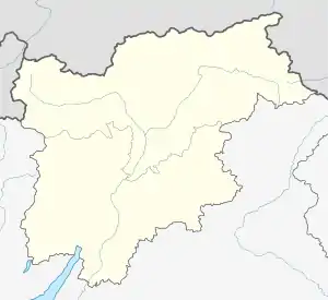 Vermiglio Vermiglio (Trentino-Alto Adige/Südtirol) | |
| Coordinates: 46°18′N 10°41′E / 46.300°N 10.683°E | |
| Country | Italy |
| Region | Trentino-Alto Adige/Südtirol |
| Province | Trento (TN) |
| Frazioni | Pizzano, Fraviano, Cortina, Borgonuovo, Stavel, Velon, Passo del Tonale |
| Area | |
| • Total | 103.7 km2 (40.0 sq mi) |
| Elevation | 1,261 m (4,137 ft) |
| Population (Dec. 2004)[2] | |
| • Total | 1,884 |
| • Density | 18/km2 (47/sq mi) |
| Demonym | Vermigliani |
| Time zone | UTC+1 (CET) |
| • Summer (DST) | UTC+2 (CEST) |
| Postal code | 38029 |
| Dialing code | 0463 |
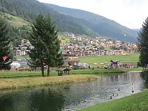
Vermiglio lake
Vermiglio (local dialect: Verméi) is a comune (municipality) in the province of Trento in the northern Italian region Trentino-Alto Adige/Südtirol, located about 40 kilometres (25 mi) northwest of the city of Trento. As of 31 December 2004, it had a population of 1,884 and an area of 103.7 square kilometres (40.0 sq mi).[3]
The municipality of Vermiglio contains the frazioni (subdivisions, mainly villages and hamlets) Pizzano, Fraviano, Cortina, Borgonuovo, Stavel, Velon and Passo del Tonale.
Vermiglio borders the following municipalities: Peio, Ponte di Legno, Ossana, Pellizzano, Giustino, Spiazzo, Strembo and Carisolo.
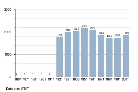
Demographic evolution
References
- ↑ "Superficie di Comuni Province e Regioni italiane al 9 ottobre 2011". Italian National Institute of Statistics. Retrieved 16 March 2019.
- ↑ "Popolazione Residente al 1° Gennaio 2018". Italian National Institute of Statistics. Retrieved 16 March 2019.
- ↑ All demographics and other statistics: Italian statistical institute Istat.

This article is issued from Wikipedia. The text is licensed under Creative Commons - Attribution - Sharealike. Additional terms may apply for the media files.