Urma
उर्मा | |
|---|---|
 Urma Location in Nepal | |
| Coordinates: 28°43′N 80°43′E / 28.71°N 80.71°E | |
| Country | |
| Zone | Seti Zone |
| District | Kailali District |
| Population (1991) | |
| • Total | 7,997 |
| Time zone | UTC+5:45 (Nepal Time) |
Urma was a village development committee in Kailali District in the Seti Zone of western Nepal. It was merged into Dhangadhi in 2015.[1] At the time of the 1991 Nepal census it had a population of 7,997, living in 845 individual households.[2]
References
- ↑ "26 new Municipalities announced". The Rising Nepal. 18 September 2015. Retrieved 1 May 2018.
- ↑ "Nepal Census 2001", Nepal's Village Development Committees, Digital Himalaya, retrieved 15 November 2009.
External links
Headquarters: Dhangadhi | ||
| Sub-metropolitan cities | 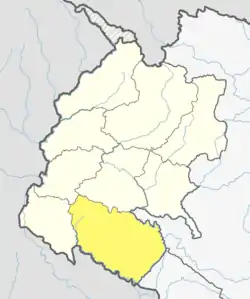 | |
| Municipalities | ||
| Rural municipalities | ||
| Former VDCs | ||
List of municipalities and rural municipalities of Nepal | ||
This article is issued from Wikipedia. The text is licensed under Creative Commons - Attribution - Sharealike. Additional terms may apply for the media files.