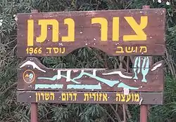
Tzur Natan
צוּר נָתָן | |
|---|---|
 | |
 Tzur Natan | |
| Coordinates: 32°14′25″N 35°0′42″E / 32.24028°N 35.01167°E | |
| Country | Israel |
| District | Central |
| Council | Drom HaSharon |
| Affiliation | Mishkei Herut Beitar |
| Founded | 1966 |
| Founded by | Nahal |
| Population (2021)[1] | 299 |
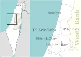
Tzur Natan (Hebrew: צוּר נָתָן, lit. Rock of Nathan) is a Moshav shitufi in central Israel. Located in western Samaria on a hilltop, 170 m above sea level, on a ridge in the foothills of the Samaritan Hills and to the south of Tayibe,[2][3] it falls under the jurisdiction of Drom HaSharon Regional Council. In 2021 it had a population of 299.[1]
History
The moshav was founded in 1966 as a Nahal settlement by Hashomer Hatzair members, and was named after Nathan Simons. It was civilianised a year later by former members of the Beitar youth group.
In 2017, a minority of Tzur Natan families agreed to sell their land to a natural gas and diesel power station to be constructed by Edeltech only meters from the Arab Israeli city of Tira.
Archaeology
In 2019, a 5th-century mosaic with Greek inscription found at an ancient wine press. The inscription reads, “Only God help the beautiful property of Master Adios, amen.” Adios was a wealthy Samaritan landowner.[4]
References
- 1 2 "Regional Statistics". Israel Central Bureau of Statistics. Retrieved 22 February 2023.
- ↑ Zur Natan - Final Report
- ↑ Introduction to the Excavations at Zur Natan, E. Ayalon, E. Matthews, W. Neidinger, Texas foundation for Archaeological and Historical Research, 1994
- ↑ 5th century Greek inscription found at site of ancient Samaritan rebellion