Tuần Giáo District
Huyện Tuần Giáo | |
|---|---|
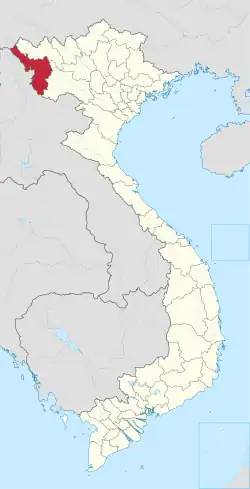
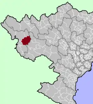 District location in northern Vietnam | |
| Country | |
| Region | Northwest |
| Province | Điện Biên |
| Capital | Tuần Giáo |
| Area | |
| • Total | 438.72 sq mi (1,136.29 km2) |
| Population (2006) | |
| • Total | 71,423 |
| • Density | 160/sq mi (63/km2) |
| Time zone | UTC+07:00 (Indochina Time) |
Tuần Giáo is a rural district of Điện Biên province in the Northwest region of Vietnam. As of 2006, the district had a population of 71,423.[1] The district covers an area of 1,136.29 km². The district capital lies at Tuần Giáo.[1]
On 24 June 1983, a 6.7 earthquake occurred in Tuần Giáo at around 14:00 local time, 11 km northeast of Tuần Giáo townlet, causing heavy losses to the Tuần Giáo district and surrounding areas. After the event, a series of aftershocks occurred, with the largest occurring on 15 July 1983 with a magnitude of 5.4.[2]
In 2006, a portion of the district was carved out to form Mường Ảng district.
Administrative divisions
Tuan Giao has 14 administrative units, including 1 town and 13 communes:
Climate
| Climate data for Tuần Giáo | |||||||||||||
|---|---|---|---|---|---|---|---|---|---|---|---|---|---|
| Month | Jan | Feb | Mar | Apr | May | Jun | Jul | Aug | Sep | Oct | Nov | Dec | Year |
| Record high °C (°F) | 31.0 (87.8) |
36.3 (97.3) |
36.8 (98.2) |
37.3 (99.1) |
37.4 (99.3) |
36.6 (97.9) |
36.3 (97.3) |
36.4 (97.5) |
36.4 (97.5) |
35.1 (95.2) |
34.0 (93.2) |
31.4 (88.5) |
37.4 (99.3) |
| Mean daily maximum °C (°F) | 22.4 (72.3) |
24.7 (76.5) |
28.1 (82.6) |
30.6 (87.1) |
31.1 (88.0) |
30.6 (87.1) |
30.2 (86.4) |
30.4 (86.7) |
30.2 (86.4) |
28.4 (83.1) |
25.5 (77.9) |
22.9 (73.2) |
27.9 (82.2) |
| Daily mean °C (°F) | 15.1 (59.2) |
16.8 (62.2) |
19.9 (67.8) |
23.0 (73.4) |
24.8 (76.6) |
25.4 (77.7) |
25.3 (77.5) |
25.1 (77.2) |
24.2 (75.6) |
22.0 (71.6) |
18.7 (65.7) |
15.4 (59.7) |
21.3 (70.3) |
| Mean daily minimum °C (°F) | 11.1 (52.0) |
12.1 (53.8) |
14.7 (58.5) |
18.3 (64.9) |
21.0 (69.8) |
22.6 (72.7) |
22.6 (72.7) |
22.3 (72.1) |
20.9 (69.6) |
18.5 (65.3) |
15.0 (59.0) |
11.6 (52.9) |
17.6 (63.7) |
| Record low °C (°F) | −0.6 (30.9) |
2.7 (36.9) |
4.1 (39.4) |
10.3 (50.5) |
13.9 (57.0) |
14.3 (57.7) |
19.0 (66.2) |
17.1 (62.8) |
11.5 (52.7) |
7.7 (45.9) |
3.6 (38.5) |
−0.4 (31.3) |
−0.6 (30.9) |
| Average precipitation mm (inches) | 26.7 (1.05) |
25.9 (1.02) |
58.7 (2.31) |
135.6 (5.34) |
216.8 (8.54) |
286.3 (11.27) |
316.7 (12.47) |
276.3 (10.88) |
137.8 (5.43) |
65.8 (2.59) |
40.5 (1.59) |
25.7 (1.01) |
1,612.9 (63.50) |
| Average rainy days | 4.8 | 4.2 | 6.5 | 13.2 | 17.4 | 21.3 | 23.2 | 21.2 | 13.7 | 8.9 | 5.8 | 3.9 | 144.4 |
| Average relative humidity (%) | 82.6 | 79.5 | 77.8 | 79.5 | 81.8 | 85.1 | 86.3 | 86.8 | 85.9 | 84.8 | 84.6 | 83.8 | 83.2 |
| Mean monthly sunshine hours | 141.8 | 152.0 | 178.3 | 199.0 | 193.2 | 132.4 | 132.7 | 149.5 | 162.4 | 158.8 | 150.1 | 145.9 | 1,896.3 |
| Source: Vietnam Institute for Building Science and Technology[3] | |||||||||||||
References
- 1 2 "Districts of Vietnam". Statoids. Retrieved 13 March 2009.
- ↑ "The Catalogue of earthquakes in the territory".
- ↑ "Vietnam Institute for Building Science and Technology" (PDF). Retrieved 16 August 2023.
21°40′01″N 103°19′59″E / 21.667°N 103.333°E
Capital: Điện Biên Phủ | ||
| Điện Biên Phủ |
|  |
| Mường Lay | ||
| Điện Biên |
| |
| Điện Biên Đông | ||
| Mường Ảng |
| |
| Mường Chà |
| |
| Mường Nhé | ||
| Nậm Pồ | ||
| Tủa Chùa | ||
| Tuần Giáo |
| |
| Điện Biên province | 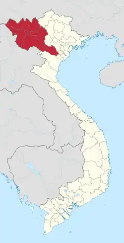 | |
|---|---|---|
| Hòa Bình province | ||
| Lai Châu province | ||
| Lào Cai province | ||
| Sơn La province | ||
| Yên Bái province | ||
※ denotes provincial seat. | ||
This article is issued from Wikipedia. The text is licensed under Creative Commons - Attribution - Sharealike. Additional terms may apply for the media files.