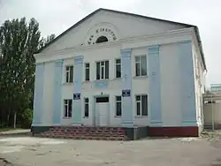
Teploklyuchenka
Теплоключенка | |
|---|---|
 | |
 Teploklyuchenka | |
| Coordinates: 42°30′00″N 78°31′30″E / 42.50000°N 78.52500°E | |
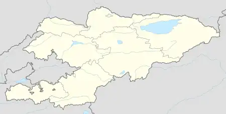
| Country | Kyrgyzstan |
| Region | Issyk-Kul |
| District | Ak-Suu |
| Established | 1868 |
| Area | |
| • Total | 8 km2 (3 sq mi) |
| Elevation | 1,810 m (5,940 ft) |
| Population (2023)[1] | |
| • Total | 14,055 |
| Time zone | UTC+6 |
| Website | teplokluchenka |
Teploklyuchenka (Russian: Теплоключенка, Kyrgyz: Теплоключенка, also Ак-Суу - Ak-Suu) is a large village in the Issyk-Kul Region of Kyrgyzstan with population of 14,009 in 2021.[1] It is the administrative center of the Ak-Suu District and of the Teploklyuchenka village community.[2] It was established in 1868, when 14 families of migrant peasants from Russian Empire settled near Aksuu Fort.
Population
| Year | Pop. | ±% p.a. |
|---|---|---|
| 2009 | 10,823 | — |
| 2021 | 2,546 | −11.36% |
| Note: resident population; Sources:[1][3] | ||
References
- 1 2 3 "Population of regions, districts, towns, urban-type settlements, rural communities and villages of Kyrgyz Republic" (XLS) (in Russian). National Statistics Committee of the Kyrgyz Republic. 2021. Archived from the original on 10 November 2021.
- ↑ "Classification system of territorial units of the Kyrgyz Republic" (in Kyrgyz). National Statistics Committee of the Kyrgyz Republic. May 2021. pp. 9–10.
- ↑ "2009 population and housing census of the Kyrgyz Republic: Issyk-Kul Region" (PDF) (in Russian). National Statistics Committee of the Kyrgyz Republic. 2010. p. 220.
This article is issued from Wikipedia. The text is licensed under Creative Commons - Attribution - Sharealike. Additional terms may apply for the media files.