Summer Set, Missouri | |
|---|---|
 Summer Set  Summer Set | |
| Coordinates: 38°5′25″N 90°34′31″W / 38.09028°N 90.57528°W | |
| Country | United States |
| State | Missouri |
| County | Jefferson |
| Township | Valle |
| Area | |
| • Total | 1.05 sq mi (2.73 km2) |
| • Land | 0.91 sq mi (2.36 km2) |
| • Water | 0.14 sq mi (0.36 km2) 1% |
| Elevation | 680 ft (210 m) |
| Population (2020) | |
| • Total | 1,127 |
| • Density | 1,235.75/sq mi (477.12/km2) |
| Time zone | UTC-6 (Central (CST)) |
| • Summer (DST) | UTC-5 (CDT) |
| ZIP Code | 63020 (De Soto) |
| Area code | 636 |
| FIPS code | 29-71508 |
| GNIS feature ID | 2806410[2] |
Summer Set is an unincorporated community and census-designated place (CDP) in Jefferson County, Missouri, United States. It is in the southern part of the county, 3 miles (5 km) south of De Soto. It is a residential community built around three artificial lakes: Summerset Lake, Winterhaven Lake, and Spring Lake.
Summer Set was first listed as a CDP prior to the 2020 census.[2]
Demographics
| Census | Pop. | Note | %± |
|---|---|---|---|
| 2020 | 1,127 | — | |
| U.S. Decennial Census[3] | |||
References
- ↑ "ArcGIS REST Services Directory". United States Census Bureau. Retrieved August 28, 2022.
- 1 2 3 "Summer Set Census Designated Place". Geographic Names Information System. United States Geological Survey, United States Department of the Interior.
- ↑ "Census of Population and Housing". Census.gov. Retrieved June 4, 2016.
Municipalities and communities of Jefferson County, Missouri, United States | ||
|---|---|---|
| Cities | 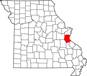 Map of Missouri highlighting Jefferson County | |
| Villages | ||
| Townships | ||
| CDPs | ||
| Other communities |
| |
This article is issued from Wikipedia. The text is licensed under Creative Commons - Attribution - Sharealike. Additional terms may apply for the media files.