Strymoniko
Στρυμονικό | |
|---|---|
 Strymoniko Location within the regional unit 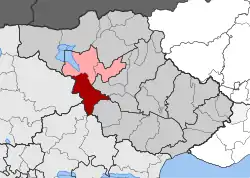 | |
| Coordinates: 41°03′N 23°19′E / 41.050°N 23.317°E | |
| Country | Greece |
| Administrative region | Central Macedonia |
| Regional unit | Serres |
| Municipality | Irakleia |
| • Municipal unit | 156.9 km2 (60.6 sq mi) |
| Population (2011)[1] | |
| • Municipal unit | 3,918 |
| • Municipal unit density | 25/km2 (65/sq mi) |
| Community | |
| • Population | 1,619 (2011) |
| Time zone | UTC+2 (EET) |
| • Summer (DST) | UTC+3 (EEST) |
| Vehicle registration | ΕΡ |
| Website | http://www.strymoniko.com |
Strymoniko (Greek: Στρυμονικό) is a village and a former municipality in the Serres regional unit, Greece. Since the 2011 local government reform it is part of the municipality Irakleia, of which it is a municipal unit.[2] The municipal unit has an area of 156.850 km2.[3] Population 3,918 (2011).
References
- 1 2 "Απογραφή Πληθυσμού - Κατοικιών 2011. ΜΟΝΙΜΟΣ Πληθυσμός" (in Greek). Hellenic Statistical Authority.
- ↑ "ΦΕΚ B 1292/2010, Kallikratis reform municipalities" (in Greek). Government Gazette.
- ↑ "Population & housing census 2001 (incl. area and average elevation)" (PDF) (in Greek). National Statistical Service of Greece.
This article is issued from Wikipedia. The text is licensed under Creative Commons - Attribution - Sharealike. Additional terms may apply for the media files.