Stockheim | |
|---|---|
 Church of Saint Wolfgang | |
 Coat of arms | |
Location of Stockheim within Kronach district 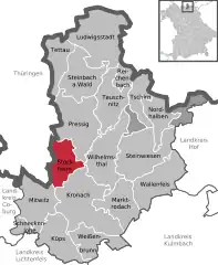 | |
 Stockheim  Stockheim | |
| Coordinates: 50°18′17″N 11°17′01″E / 50.30472°N 11.28361°E | |
| Country | Germany |
| State | Bavaria |
| Admin. region | Oberfranken |
| District | Kronach |
| Subdivisions | 7 Gemeindeteile |
| Government | |
| • Mayor (2023–29) | Daniel Weißerth[1] (CSU) |
| Area | |
| • Total | 25.37 km2 (9.80 sq mi) |
| Elevation | 354 m (1,161 ft) |
| Population (2022-12-31)[2] | |
| • Total | 4,853 |
| • Density | 190/km2 (500/sq mi) |
| Time zone | UTC+01:00 (CET) |
| • Summer (DST) | UTC+02:00 (CEST) |
| Postal codes | 96342 |
| Dialling codes | 09265 |
| Vehicle registration | KC |
| Website | www.stockheim-online.de |
Stockheim is a municipality in the district of Kronach in Bavaria in Germany. It is located on Bundesstraße 85, and on the touristic route Bier- und Burgenstraße (Beer- and Castle Road).
References
- ↑ Liste der ersten Bürgermeister/Oberbürgermeister in kreisangehörigen Gemeinden, Bayerisches Landesamt für Statistik. Retrieved 5 September 2023.
- ↑ Genesis Online-Datenbank des Bayerischen Landesamtes für Statistik Tabelle 12411-003r Fortschreibung des Bevölkerungsstandes: Gemeinden, Stichtag (Einwohnerzahlen auf Grundlage des Zensus 2011)
Towns and municipalities in Kronach (district) | ||
|---|---|---|
Coat of Arms of Kronach district | ||
This article is issued from Wikipedia. The text is licensed under Creative Commons - Attribution - Sharealike. Additional terms may apply for the media files.