Shahrak
شهرک | |
|---|---|
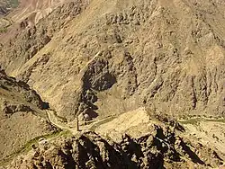 The Minaret of Jam seen from overhead | |
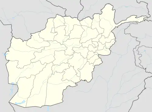 Shahrak Location within Afghanistan | |
| Coordinates: 34°06′00″N 64°16′00″E / 34.1000°N 64.2667°E | |
| Country | |
| Province | Ghor |
| Center | Dahan-e Falezak |
| Area | |
| • Total | 4,350 km2 (1,680 sq mi) |
| Population (2012)[1] | |
| • Total | 58,200 |
Shahrak District is located in the western part of Ghor province, Afghanistan. The population is 58,200.[1] The district center is Dahan-e Falezak.
Economy
The district suffers from a weak economy and severe poverty due to lack of road linkage between villages and district centre, low level of agriculture and livestock productions, inaccessibility to healthcare services and security problems.[2] In 2014, construction work of irrigation projects began in five villages of the district by the Ministry of Rural Rehabilitation and Development (MRRD).[3]
- Main handicrafts: rug weaving.
- Agricultural products: wheat, barley and potato.
Architecture
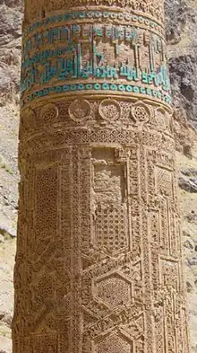
Near the village of Jam stands the Minaret of Jam, a historic building.
Climate
Shahrak features a mediterranean-influenced humid continental climate (Köppen: Dsb) with warm summers and cold, snowy winters.
Afghanistan’s lowest recorded temperature of −52.2 °C (−62.0 °F) was observed at Shahrak.[4]
| Climate data for Shahrak, elevation: 2,325 metres (7,628.0 ft) | |||||||||||||
|---|---|---|---|---|---|---|---|---|---|---|---|---|---|
| Month | Jan | Feb | Mar | Apr | May | Jun | Jul | Aug | Sep | Oct | Nov | Dec | Year |
| Record high °C (°F) | 9.8 (49.6) |
16.3 (61.3) |
24.1 (75.4) |
24.7 (76.5) |
31.0 (87.8) |
34.6 (94.3) |
36.2 (97.2) |
34.4 (93.9) |
29.9 (85.8) |
26.2 (79.2) |
19.1 (66.4) |
15.2 (59.4) |
36.2 (97.2) |
| Mean daily maximum °C (°F) | −1.5 (29.3) |
−0.9 (30.4) |
8.7 (47.7) |
16.8 (62.2) |
18.6 (65.5) |
26.6 (79.9) |
28.5 (83.3) |
26.5 (79.7) |
23.0 (73.4) |
17.2 (63.0) |
9.7 (49.5) |
3.9 (39.0) |
14.8 (58.6) |
| Daily mean °C (°F) | −8.0 (17.6) |
−8.5 (16.7) |
2.2 (36.0) |
9.4 (48.9) |
10.5 (50.9) |
16.8 (62.2) |
18.4 (65.1) |
16.1 (61.0) |
12.0 (53.6) |
7.8 (46.0) |
1.6 (34.9) |
−3.3 (26.1) |
6.3 (43.3) |
| Mean daily minimum °C (°F) | −14.5 (5.9) |
−16.0 (3.2) |
−4.3 (24.3) |
1.9 (35.4) |
2.3 (36.1) |
7.0 (44.6) |
8.2 (46.8) |
5.6 (42.1) |
0.9 (33.6) |
−1.6 (29.1) |
−6.6 (20.1) |
−10.5 (13.1) |
−2.3 (27.9) |
| Record low °C (°F) | −52.2 (−62.0) |
−46.1 (−51.0) |
−22.0 (−7.6) |
−6.0 (21.2) |
−5.0 (23.0) |
2.0 (35.6) |
3.0 (37.4) |
0.0 (32.0) |
−3.0 (26.6) |
−8.0 (17.6) |
−18.0 (−0.4) |
−29.0 (−20.2) |
−52.2 (−62.0) |
| Average precipitation mm (inches) | 53.6 (2.11) |
68.2 (2.69) |
83.0 (3.27) |
59.3 (2.33) |
35.7 (1.41) |
10.4 (0.41) |
3.7 (0.15) |
5.6 (0.22) |
0.3 (0.01) |
6.8 (0.27) |
20.4 (0.80) |
42.8 (1.69) |
389.8 (15.36) |
| Average relative humidity (%) | 61.4 | 62.2 | 59.7 | 55.0 | 45.7 | 34.0 | 31.4 | 31.2 | 32.6 | 39.6 | 46.4 | 57.6 | 46.4 |
| Source 1: Meteo-Climat[5] | |||||||||||||
| Source 2: Weatherbase (Precipitation & Humidity),[6] The Prediction Of Worldwide Energy Resources (Record High (1990-2021))[7] | |||||||||||||
References
- 1 2 "Settled Population of Ghor Province" (PDF). Central Statistics Organization. Retrieved 24 November 2015.
- ↑ "Summary of District Development Plan" (PDF). Shahrak District Development Assembly. Retrieved 24 November 2015.
- ↑ "Construction work of five various projects starts in Ghor province". Ministry of Rural Rehabilitation and Development. Retrieved 24 November 2015.
- ↑ Afghanistan Constitution and Citizenship Law Handboook - Strategic Information and Basic Laws. 4 April 2013. ISBN 9781438778358. Retrieved 13 September 2022.
- ↑ "Shahrak. meteo-climat.org". Retrieved 8 September 2022.
- ↑ "Shahrak. Weatherbase.com". Retrieved 13 September 2022.
- ↑ "Native Resolution Climatologiy Climatologies 32-year Meteorological and Solar Monthly & Annual Climatologies". Retrieved 24 September 2022.
External links
- Map of Settlements IMMAP, August 2011
| Districts | 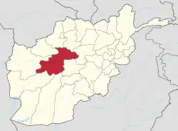 | |
|---|---|---|
| Populated places | ||
| Other | ||