Serra de' Conti | |
|---|---|
| Comune di Serra de' Conti | |
Location of Serra de' Conti | |
 Serra de' Conti Location of Serra de' Conti in Italy  Serra de' Conti Serra de' Conti (Marche) | |
| Coordinates: 43°33′N 13°2′E / 43.550°N 13.033°E | |
| Country | Italy |
| Region | Marche |
| Province | Ancona (AN) |
| Frazioni | Osteria |
| Government | |
| • Mayor | Letizia Perticaroli |
| Area | |
| • Total | 24.51 km2 (9.46 sq mi) |
| Elevation | 261 m (856 ft) |
| Population (2013)[2] | |
| • Total | 3,678 |
| • Density | 150/km2 (390/sq mi) |
| Demonym | Serrani |
| Time zone | UTC+1 (CET) |
| • Summer (DST) | UTC+2 (CEST) |
| Postal code | 60030 |
| Dialing code | 0731 |
| Patron saint | Bl. Gherardo di Serradeconti |
| Website | Official website |
Serra de' Conti is a comune (municipality) in the Province of Ancona in the Italian region Marche, located about 40 kilometres (25 mi) west of Ancona.
Serra de' Conti borders the following municipalities: Arcevia, Barbara, Montecarotto, Ostra Vetere.
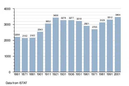
Demographic evolution
References
- ↑ "Superficie di Comuni Province e Regioni italiane al 9 ottobre 2011". Italian National Institute of Statistics. Retrieved 16 March 2019.
- ↑ All demographics and other statistics: Italian statistical institute Istat.
External links
This article is issued from Wikipedia. The text is licensed under Creative Commons - Attribution - Sharealike. Additional terms may apply for the media files.