Schirgiswalde-Kirschau | |
|---|---|
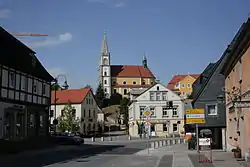 Main street with the Church of the Assumption of the Virgin Mary | |
Location of Schirgiswalde-Kirschau within Bautzen district 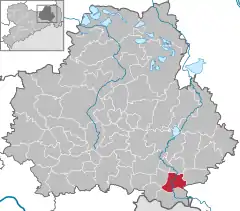 | |
 Schirgiswalde-Kirschau  Schirgiswalde-Kirschau | |
| Coordinates: 51°6′N 14°26′E / 51.100°N 14.433°E | |
| Country | Germany |
| State | Saxony |
| District | Bautzen |
| Government | |
| • Mayor (2018–25) | Sven Gabriel[1] (FDP) |
| Area | |
| • Total | 24.3 km2 (9.4 sq mi) |
| Elevation | 250 m (820 ft) |
| Population (2021-12-31)[2] | |
| • Total | 6,084 |
| • Density | 250/km2 (650/sq mi) |
| Time zone | UTC+01:00 (CET) |
| • Summer (DST) | UTC+02:00 (CEST) |
| Postal codes | 02681 |
| Dialling codes | 03592, 035938 |
| Vehicle registration | BZ, BIW, HY, KM |
| Website | https://www.stadt-schirgiswalde-kirschau.de/ |
Schirgiswalde-Kirschau (Sorbian: Šěrachow-Korzym, pronounced [ˈʃɪʁaxɔf ˈkɔʁzɨm]) is a town in the district of Bautzen, in Saxony, Germany. It was formed on January 1, 2011 by the merger of the former municipalities Schirgiswalde, Kirschau and Crostau.[3]
References
- ↑ Bürgermeisterwahlen 2018, Freistaat Sachsen, accessed 10 July 2021.
- ↑ "Bevölkerung des Freistaates Sachsen nach Gemeinden am 31. Dezember 2021" (XLS) (in German). Statistisches Landesamt des Freistaates Sachsen. 2022.
- ↑ Gebietsänderungen vom 01. Januar bis 31. Dezember 2011, Statistisches Bundesamt
This article is issued from Wikipedia. The text is licensed under Creative Commons - Attribution - Sharealike. Additional terms may apply for the media files.