Santol | |
|---|---|
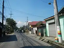
 Street view of the barangay | |
.svg.png.webp) Santol .svg.png.webp) Santol | |
| Coordinates: 14°51′27″N 120°54′56″E / 14.85750°N 120.91556°E | |
| Country | |
| Region | Central Luzon |
| Province | Bulacan |
| City | Balagtas |
| Elevation | 8 m (26 ft) |
| Population (2020) | |
| • Total | 17,050 |
| Time zone | UTC+8 (PST) |
| ZIP code | 3016 |
Santol is a barangay in Balagtas, Bulacan, Central Luzon, Philippines. It shares border with Pulong Gubat in the north, and Dalig in the south. In 2020, Santol has a total population of 17,050.[1]
Geography
Santol is located in the northern portion of Balagtas, on the western bank of a local river. Its average elevation is at 8 meters above the sea level.[2]
External links
 Media related to Santol, Balagtas, Bulacan at Wikimedia Commons
References
- ↑ "Census of Population (2020) Region III (Central Luzon)". psa.gov.ph. Bulacan: Philippine Statistics Authority. Archived from the original on 2023-04-04. Retrieved 2023-04-06.
- ↑ "Santol topographic map, elevation, terrain". Topographic maps. Retrieved 2023-04-07.
This article is issued from Wikipedia. The text is licensed under Creative Commons - Attribution - Sharealike. Additional terms may apply for the media files.