| Santiam Lake | |
|---|---|
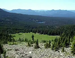 The lake as seen from Three Fingered Jack | |
 Santiam Lake  Santiam Lake | |
| Location | Oregon Cascades NW of Santiam Pass, Linn County, Oregon, United States |
| Coordinates | 44°28′41″N 121°53′06″W / 44.47792°N 121.88496°W |
| Type | Paternoster lake |
| Primary outflows | North Santiam River |
| Basin countries | United States |
| Max. length | 1,000 ft (300 m) |
| Max. width | 1,000 ft (300 m) |
| Surface elevation | 5,124 ft (1,562 m) |
| Frozen | winter and spring |
| Islands | none |
| Settlements | none |
.jpg.webp)
The view of Three Fingered Jack from Santiam Lake, as seen in early Autumn.
Santiam Lake is a lake in the U.S. state of Oregon, west of Three Fingered Jack in the Cascade Range. It is headwaters for the North Santiam River and drains a portion of the southwestern Mount Jefferson Wilderness.[1] The lake is stocked bi-annually with Brook and Rainbow trout.[2] It can be accessed from various trails in the Jefferson Wilderness, including Santiam Lake Trail #3491.[3] It is located about 6.5 miles northwest of Santiam Junction, Oregon.
See also
- List of lakes in Oregon
.jpg.webp) Panoramic View of Santiam Lake in early Autumn.
Panoramic View of Santiam Lake in early Autumn.
References
- ↑ "Mount Jefferson Wilderness". U.S. Forest Service. Retrieved December 10, 2013.
- ↑ "Cascade Ramblings - Cascader: Santiam Lake: Mt Jefferson Wilderness". www.cascaderamblings.com. Retrieved 2022-10-12.
- ↑ "Willamette National Forest - Santiam Lake Trail #3491". USDA Forest Service. Archived from the original on 12 October 2022. Retrieved 11 October 2022.
This article is issued from Wikipedia. The text is licensed under Creative Commons - Attribution - Sharealike. Additional terms may apply for the media files.