San Martino in Strada | |
|---|---|
| Comune di San Martino in Strada | |
 | |
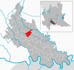 | |
Location of San Martino in Strada | |
 San Martino in Strada Location of San Martino in Strada in Italy  San Martino in Strada San Martino in Strada (Lombardy) | |
| Coordinates: 45°18′N 9°35′E / 45.300°N 9.583°E | |
| Country | Italy |
| Region | Lombardy |
| Province | Lodi (LO) |
| Frazioni | Ca' de' Bolli, Ca' del Conte, Pompola, Sesto Pergola |
| Government | |
| • Mayor | Luca Marini |
| Area | |
| • Total | 13.1 km2 (5.1 sq mi) |
| Elevation | 73 m (240 ft) |
| Population (1 January 2017)[2] | |
| • Total | 3,681 |
| • Density | 280/km2 (730/sq mi) |
| Demonym | Sammartinesi |
| Time zone | UTC+1 (CET) |
| • Summer (DST) | UTC+2 (CEST) |
| Postal code | 26817 |
| Dialing code | 0371 |
| Website | Official website |
San Martino in Strada (Lodigiano: San Martin) is a comune (municipality) in the Province of Lodi in the Italian region Lombardy, located about 40 kilometres (25 mi) southeast of Milan and about 7 kilometres (4 mi) southeast of Lodi.
San Martino in Strada borders the following municipalities: Lodi, Corte Palasio, Cavenago d'Adda, Cornegliano Laudense, Massalengo, Ossago Lodigiano.
References
- ↑ "Superficie di Comuni Province e Regioni italiane al 9 ottobre 2011". Italian National Institute of Statistics. Retrieved 16 March 2019.
- ↑ All demographics and other statistics: Italian statistical institute Istat.
External links
This article is issued from Wikipedia. The text is licensed under Creative Commons - Attribution - Sharealike. Additional terms may apply for the media files.