Saint-Thomé | |
|---|---|
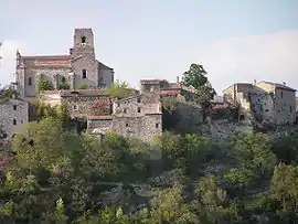 The church and surrounding buildings in Saint-Thomé | |
Location of Saint-Thomé | |
 Saint-Thomé  Saint-Thomé | |
| Coordinates: 44°30′05″N 4°37′36″E / 44.5014°N 4.6267°E | |
| Country | France |
| Region | Auvergne-Rhône-Alpes |
| Department | Ardèche |
| Arrondissement | Privas |
| Canton | Berg-Helvie |
| Government | |
| • Mayor (2020–2026) | Gilbert Petitjean[1] |
| Area 1 | 19.65 km2 (7.59 sq mi) |
| Population | 470 |
| • Density | 24/km2 (62/sq mi) |
| Time zone | UTC+01:00 (CET) |
| • Summer (DST) | UTC+02:00 (CEST) |
| INSEE/Postal code | 07300 /07220 |
| Elevation | 93–380 m (305–1,247 ft) (avg. 67 m or 220 ft) |
| 1 French Land Register data, which excludes lakes, ponds, glaciers > 1 km2 (0.386 sq mi or 247 acres) and river estuaries. | |
Saint-Thomé (French pronunciation: [sɛ̃ tɔme]; Occitan: Sant Thomé) is a commune in the Ardèche department in southern France.
Population
| Year | Pop. | ±% |
|---|---|---|
| 1962 | 288 | — |
| 1968 | 288 | +0.0% |
| 1975 | 245 | −14.9% |
| 1982 | 257 | +4.9% |
| 1990 | 285 | +10.9% |
| 1999 | 363 | +27.4% |
| 2008 | 383 | +5.5% |
See also
References
- ↑ "Répertoire national des élus: les maires". data.gouv.fr, Plateforme ouverte des données publiques françaises (in French). 2 December 2020.
- ↑ "Populations légales 2021". The National Institute of Statistics and Economic Studies. 28 December 2023.
Wikimedia Commons has media related to Saint-Thomé.
This article is issued from Wikipedia. The text is licensed under Creative Commons - Attribution - Sharealike. Additional terms may apply for the media files.