Sabarimala | |
|---|---|
Hill | |
 | |
 Sabarimala | |
| Coordinates: 9°26′15″N 77°04′50″E / 9.4375°N 77.0805°E | |
| Country | India |
| State | Kerala |
| District | Pathanamthitta District |
| Elevation | 1,260 m (4,130 ft) |
| Languages | |
| Time zone | UTC+5:30 (IST) |
| Telephone code | 0473 |
| Vehicle registration | KL-03, KL-62 |
| Website | www |
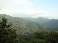
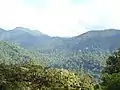
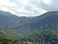
Sabarimala is a hill situated in Perinad village, Ranni Taluk, Pathanamthitta district in Kerala State.[1] This hill is situated at 72 kilometers from Pathanamthitta town.[1] The distance from Ranni to Sabarimala is 60 kilometers. A motorable road is built from Ranni to Pampa, valley of Sabarimala hills. Sabarimala Sree Dharmasastha Temple,[2] Malikappuram Temple are situated in one side of this hills.[3][4] Sabarimala is a part of periyar tiger reserve and Western ghats. The height of Sabarimala from mean sea level is 1,260 meters.
Gallery
View of Hills

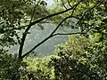
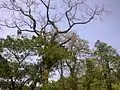
Flora of Sabarimala hills


References
- 1 2 "Sabarimala | Pathanamthitta District, Government of Kerala". Retrieved 30 January 2019.
- ↑ "Sabarimala". sabarimala.kerala.gov.in. Retrieved 30 January 2019.
- ↑ "Kerala Temples in Sabarimala - Malikappuram Temple". keralatemples.info. Retrieved 30 January 2019.
- ↑ "Malikappurathamma Temple | Sabarimala". sabarimala.net. Retrieved 30 January 2019.
This article is issued from Wikipedia. The text is licensed under Creative Commons - Attribution - Sharealike. Additional terms may apply for the media files.