Rountzenheim
Runzenem | |
|---|---|
Part of Rountzenheim-Auenheim | |
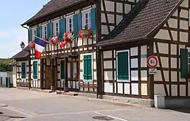 Mairie | |
.svg.png.webp) Coat of arms | |
Location of Rountzenheim | |
 Rountzenheim 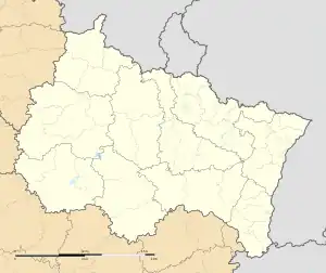 Rountzenheim | |
| Coordinates: 48°49′11″N 8°00′25″E / 48.8197°N 8.0069°E | |
| Country | France |
| Region | Grand Est |
| Department | Bas-Rhin |
| Arrondissement | Haguenau-Wissembourg |
| Canton | Bischwiller |
| Commune | Rountzenheim-Auenheim |
| Area 1 | 6.67 km2 (2.58 sq mi) |
| Population (2019)[1] | 1,042 |
| • Density | 160/km2 (400/sq mi) |
| Time zone | UTC+01:00 (CET) |
| • Summer (DST) | UTC+02:00 (CEST) |
| Postal code | 67480 |
| Elevation | 116–121 m (381–397 ft) |
| 1 French Land Register data, which excludes lakes, ponds, glaciers > 1 km2 (0.386 sq mi or 247 acres) and river estuaries. | |
Rountzenheim (French pronunciation: [ʁuntsənaim]; German: Runzenheim; Alsatian: Runzenem) is a former commune in the Bas-Rhin department in Grand Est in north-eastern France.[2] On 1 January 2019, it was merged into the new commune Rountzenheim-Auenheim.[3]
See also
References
- ↑ Téléchargement du fichier d'ensemble des populations légales en 2019, INSEE
- ↑ Des villages de Cassini aux communes d'aujourd'hui: Commune data sheet Rountzenheim, EHESS (in French).
- ↑ Arrêté préfectoral 4 September 2018 (in French)
Wikimedia Commons has media related to Rountzenheim.
This article is issued from Wikipedia. The text is licensed under Creative Commons - Attribution - Sharealike. Additional terms may apply for the media files.