| Roudoule | |
|---|---|
 | |
  | |
| Location | |
| Country | France |
| Physical characteristics | |
| Mouth | |
• location | Var |
• coordinates | 43°57′17″N 6°53′39″E / 43.95472°N 6.89417°E |
| Length | 13.1 km (8.1 mi) |
| Basin features | |
| Progression | Var→ Mediterranean Sea |
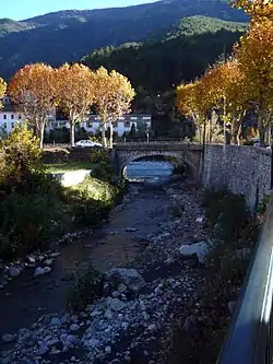
The Roudoule (French pronunciation: [ʁudul]; Occitan: Rodola) is a 13.1-kilometre (8.1 mi) long river that flows through the Alpes-Maritimes department of south-eastern France.[1] It flows into the Var in Puget-Théniers. The Mayola is one of its tributaries.
References
This article is issued from Wikipedia. The text is licensed under Creative Commons - Attribution - Sharealike. Additional terms may apply for the media files.