Rohr bei Hartberg | |
|---|---|
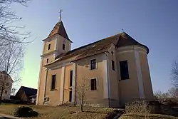 Catholic church in Unterrohr | |
 Coat of arms | |
 Rohr bei Hartberg Location within Austria | |
| Coordinates: 47°14′15″N 16°03′09″E / 47.23750°N 16.05250°E | |
| Country | Austria |
| State | Styria |
| District | Hartberg-Fürstenfeld |
| Government | |
| • Mayor | Adolf Schuller (ÖVP) |
| Area | |
| • Total | 27.7 km2 (10.7 sq mi) |
| Elevation | 356 m (1,168 ft) |
| Population (2018-01-01)[2] | |
| • Total | 1,457 |
| • Density | 53/km2 (140/sq mi) |
| Time zone | UTC+1 (CET) |
| • Summer (DST) | UTC+2 (CEST) |
| Postal code | 8294, 8274 |
| Area code | 03332 |
| Vehicle registration | HB |
| Website | www.rohr-hartberg. steiermark.at |
Rohr bei Hartberg is a municipality in the district of Hartberg-Fürstenfeld in Styria, Austria.
References
- ↑ "Dauersiedlungsraum der Gemeinden Politischen Bezirke und Bundesländer - Gebietsstand 1.1.2018". Statistics Austria. Retrieved 10 March 2019.
- ↑ "Einwohnerzahl 1.1.2018 nach Gemeinden mit Status, Gebietsstand 1.1.2018". Statistics Austria. Retrieved 9 March 2019.
This article is issued from Wikipedia. The text is licensed under Creative Commons - Attribution - Sharealike. Additional terms may apply for the media files.