| Regions of Togo Régions du Togo (French) | |
|---|---|
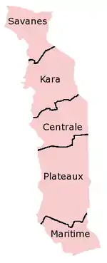 A clickable map of Togo exhibiting its five regions. | |
| Category | Unitary State |
| Location | Togolese Republic |
| Number | 5 |
| Populations | 617,871 (Centrale) – 2,599,955 (Maritime) |
| Areas | 6,200 km2 (2,400 sq mi) (Maritime) – 16,970 km2 (6,554 sq mi) (Plateaux) |
| Government |
|
| Subdivisions | |
 |
|---|
|
|
Togo is divided into five regions (régions, singular région) (capitals in parentheses):
| Region | Capital | Zone | Area (km2) [1] |
Population (2010 census) |
Prefectures |
|---|---|---|---|---|---|
| Centrale | Sokodé | North | 13,317 | 617,871 | 4 |
| Kara | Kara | North | 11,738 | 769,940 | 7 |
| Maritime | Lomé | South | 6,100 | 2,599,955 | 7 |
| Plateaux | Atakpamé | South | 16,975 | 1,375,165 | 12 |
| Savanes | Dapaong | North | 8,470 | 828,224 | 5 |
The regions are divided into 30 prefectures.
See also
References
- ↑ Togo at GeoHive Archived 2016-07-01 at the Wayback Machine
Togo articles | |||
|---|---|---|---|
| History | | ||
| Geography |
| ||
| Politics | |||
| Economy | |||
| Society | |||
| |||
This article is issued from Wikipedia. The text is licensed under Creative Commons - Attribution - Sharealike. Additional terms may apply for the media files.