Rassach | |
|---|---|
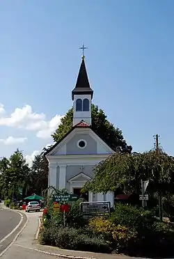 Chapel in Rassach | |
 Coat of arms | |
 Rassach Location within Austria | |
| Coordinates: 46°51′37″N 15°16′12″E / 46.86028°N 15.27000°E | |
| Country | Austria |
| State | Styria |
| District | Deutschlandsberg |
| Government | |
| • Mayor | Gernot Becwar (ÖVP) |
| Area | |
| • Total | 18.14 km2 (7.00 sq mi) |
| Elevation | 392 m (1,286 ft) |
| Population (1 January 2016)[1] | |
| • Total | 1,413 |
| • Density | 78/km2 (200/sq mi) |
| Time zone | UTC+1 (CET) |
| • Summer (DST) | UTC+2 (CEST) |
| Postal code | 8510, 8522, 8524 |
| Area code | 03464 |
| Vehicle registration | DL |
| Website | www.rassach.at |
Rassach is a former municipality in the district of Deutschlandsberg in the Austrian state of Styria. Since the 2015 Styria municipal structural reform, it is part of the municipality Stainz.[2]
Population
| Year | Pop. | ±% |
|---|---|---|
| 1869 | 1,193 | — |
| 1880 | 1,255 | +5.2% |
| 1890 | 1,328 | +5.8% |
| 1900 | 1,269 | −4.4% |
| 1910 | 1,254 | −1.2% |
| 1923 | 1,221 | −2.6% |
| 1934 | 1,189 | −2.6% |
| 1939 | 1,109 | −6.7% |
| 1951 | 1,203 | +8.5% |
| 1961 | 1,197 | −0.5% |
| 1971 | 1,238 | +3.4% |
| 1981 | 1,273 | +2.8% |
| 1991 | 1,286 | +1.0% |
| 2001 | 1,388 | +7.9% |
| 2011 | 1,436 | +3.5% |
References
This article is issued from Wikipedia. The text is licensed under Creative Commons - Attribution - Sharealike. Additional terms may apply for the media files.