| Quyqu | |
|---|---|
 Quyqu Location in Bolivia | |
| Highest point | |
| Elevation | 4,860 m (15,940 ft)[1] |
| Coordinates | 19°43′50″S 66°08′49″W / 19.73056°S 66.14694°W |
| Geography | |
| Location | Bolivia Potosí Department |
| Parent range | Andes |
Quyqu (Aymara for a kind of instrument similar to the qina,[2] also spelled Cuyco) is a mountain in Bolivia which reaches a height of approximately 4,860 m (15,945 ft). It is located in the Potosí Department, Antonio Quijarro Province, Porco Municipality. It lies southwest of Warawara Lake.[1][3]
References
- 1 2 Bolivian IGM map 1:50,000 Río San Juan 6334-I
- ↑ "Diccionario Bilingüe, Castellano - Aymara, 2002". Félix Layme Pairumani. Retrieved March 2, 2016. (see: Instrumento)
- ↑ "Porco". Archived from the original on April 28, 2016. Retrieved March 2, 2016.
Capital: Potosí | ||
| Provinces | 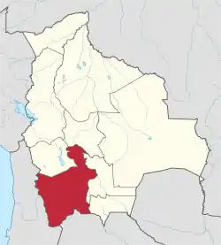 | |
| Municipalities (and seats) |
| |
This article is issued from Wikipedia. The text is licensed under Creative Commons - Attribution - Sharealike. Additional terms may apply for the media files.