Quinlan, Oklahoma | |
|---|---|
 Quinlan, Oklahoma  Quinlan, Oklahoma | |
| Coordinates: 36°27′22″N 99°02′45″W / 36.45611°N 99.04583°W | |
| Country | United States |
| State | Oklahoma |
| County | Woodward |
| Area | |
| • Total | 0.28 sq mi (0.72 km2) |
| • Land | 0.28 sq mi (0.72 km2) |
| • Water | 0.00 sq mi (0.00 km2) |
| Elevation | 1,736 ft (529 m) |
| Population (2020) | |
| • Total | 28 |
| • Density | 101.08/sq mi (38.99/km2) |
| Time zone | UTC-6 (Central (CST)) |
| • Summer (DST) | UTC-5 (CDT) |
| Area code | 580 |
| GNIS feature ID | 2805350[2] |
Quinlan is an unincorporated community in Woodward County, Oklahoma, United States.[2] Quinlan is located on the Atchison, Topeka and Santa Fe Railroad, 9 miles (14 km) east of Mooreland.
Demographics
| Census | Pop. | Note | %± |
|---|---|---|---|
| 2020 | 28 | — | |
| U.S. Decennial Census[3] | |||
References
- ↑ "ArcGIS REST Services Directory". United States Census Bureau. Retrieved September 20, 2022.
- 1 2 3 U.S. Geological Survey Geographic Names Information System: Quinlan, Oklahoma
- ↑ "Census of Population and Housing". Census.gov. Retrieved June 4, 2016.
Municipalities and communities of Woodward County, Oklahoma, United States | ||
|---|---|---|
| City | 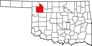 Map of Oklahoma highlighting Woodward County | |
| Towns | ||
| CDP | ||
| Other community | ||
This article is issued from Wikipedia. The text is licensed under Creative Commons - Attribution - Sharealike. Additional terms may apply for the media files.