Route 202 | ||||
|---|---|---|---|---|
 | ||||
| Route information | ||||
| Maintained by Transports Québec | ||||
| Length | 140.5 km[1] (87.3 mi) | |||
| Major junctions | ||||
| West end | ||||
| East end | ||||
| Location | ||||
| Country | Canada | |||
| Province | Quebec | |||
| Highway system | ||||
| ||||

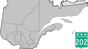
Route 202 is an east/west 140-kilometre highway in the Monteregie and Estrie regions of the province of Quebec, Canada. Its western terminus is at the junction of Route 132 in Sainte-Barbe and its eastern terminus is in southern Cowansville at the junctions of Route 104 and Route 139. The highway runs a few kilometres north of the Canada–United States border for most of its length.
Municipalities along Route 202
- Sainte-Barbe
- Huntingdon
- Hinchinbrooke
- Franklin
- Havelock
- Hemmingford (township)
- Hemmingford (village)
- Saint-Bernard-de-Lacolle
- Lacolle
- Noyan
- Clarenceville
- Venise-en-Québec
- Pike River
- Stanbridge Station
- Bedford (township)
- Bedford (city)
- Stanbridge East
- Dunham
- Cowansville
.jpg.webp) West end, at route 132.
West end, at route 132..jpg.webp) Route 202 in Huntingdon.
Route 202 in Huntingdon.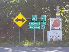 Intersection with 201 in Maritana hamlet near Franklin.
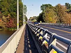 Jean-Jacques-Bertrand Bridge in Noyan, over Richelieu River.
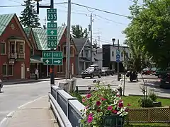 Route 202 is concurrent with Route des Vins in Bedford.
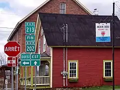 Junction with route 213 in Dunham.
Major intersections
| RCM or ET | Municipality | Km | Junction | Notes |
|---|---|---|---|---|
Western terminus of Route 202 | ||||
| Le Haut-Saint-Laurent | Sainte-Barbe | 0.0 | 132 WEST: to Saint-Anicet 132 EAST: to Saint-Stanislas-de-Kosta | |
| Huntingdon | 10.0 10.3 |
138 EAST: to Ormstown 138 WEST: to Godmanchester | ||
| Hinchinbrooke | 20.0 | Chemin Herdman | SOUTH: to | |
| Franklin | 33.8 | 209 SOUTH: to 209 NORTH: to Saint-Chrysostome | ||
| 38.6 | 201 NORTH: to Ormstown | |||
| Havelock | 47.1 | 203 SOUTH: to Cannon Corners Rd. Mooers, New York 203 NORTH: to Saint-Chrysostome | ||
| Les Jardins-de-Napierville | Hemmingford Village | 60.5 | 219 SOUTH: to County Road 22, Mooers, New York 219 NORTH: to Hemmingford (township) | |
| Saint-Bernard-de-Lacolle | 72.8 73.2 |
15 SOUTH: to 15 NORTH: to Saint-Cyprien-de-Napierville | ||
| 74.7 | 217 SOUTH: to 217 NORTH: to Saint-Cyprien-de-Napierville | |||
| Le Haut-Richelieu | Lacolle | 79.1 80.3 |
221 SOUTH: to 221 NORTH: to Napierville | |
| 83.0 | 223 SOUTH: to 223 NORTH: to Saint-Paul-de-l'Île-aux-Noix | |||
| Clarenceville | 86.5 | 225 SOUTH: to 225 NORTH: to Sainte-Anne-de-Sabrevois | ||
| Venise-en-Quebec | 100.0 | 227 NORTH: to Saint-Sébastien | ||
| Brome-Missisquoi | Pike River | 109.1 110.0 |
133 NORTH: to Saint-Sébastien 133 SOUTH: to Pike River | |
| Bedford | 116.5 116.6 |
235 NORTH: to Sainte-Sabine 235 SOUTH: to Saint-Armand | ||
| Stanbridge-East | 123.0 | 237 SOUTH: to Frelighsburg | ||
| Dunham | 132.7 | 213 SOUTH: to Frelighsburg | ||
| Cowansville | 140.5 | 104 WEST: to Brigham 104 EAST: to Lac-Brome 139 SOUTH: to Sutton 139 NORTH: to East Farnham | ||
Eastern terminus of Route 202 | ||||
See also
References
- ↑ Ministère des transports, "Distances routières", page 79, Les Publications du Québec, 2005
External links
- Provincial Route Map (Courtesy of the Quebec Ministry of Transportation) (in French)
- Route 202 in Google Maps
This article is issued from Wikipedia. The text is licensed under Creative Commons - Attribution - Sharealike. Additional terms may apply for the media files.