Perchau am Sattel | |
|---|---|
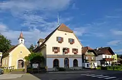 Village centre | |
 Coat of arms | |
 Perchau am Sattel Location within Austria | |
| Coordinates: 47°06′30″N 14°27′26″E / 47.10833°N 14.45722°E | |
| Country | Austria |
| State | Styria |
| District | Murau |
| Government | |
| • Mayor | Matthäus Össl (ÖVP) |
| Area | |
| • Total | 19.39 km2 (7.49 sq mi) |
| Elevation | 1,005 m (3,297 ft) |
| Population (1 January 2016)[1] | |
| • Total | 301 |
| • Density | 16/km2 (40/sq mi) |
| Time zone | UTC+1 (CET) |
| • Summer (DST) | UTC+2 (CEST) |
| Postal code | 8820 |
| Area code | 03584 |
| Vehicle registration | MU |
| Website | www.perchau-sattel.steiermark.at |
Perchau am Sattel is a former municipality in the district of Murau in the Austrian state of Styria. Since the 2015 Styria municipal structural reform, it is part of the municipality Neumarkt in der Steiermark.[2]
Geography
Perchau lies about 22 km east of Murau.
References
This article is issued from Wikipedia. The text is licensed under Creative Commons - Attribution - Sharealike. Additional terms may apply for the media files.